 SnowScope
Obergurgl snow forecast next week (23–29 November 2026): a minor top-up of 13 cm
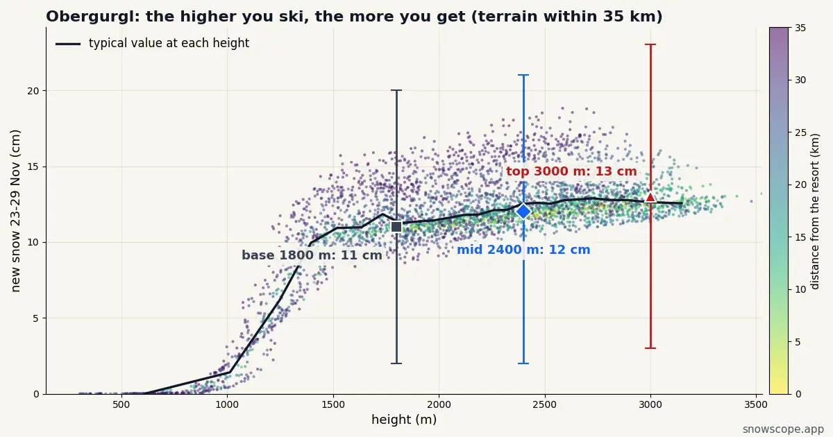
Don't plan a powder trip to Obergurgl on next week's numbers alone. From Monday 23 to Sunday 29 November we expect 13 cm at the top (3–23 cm) and 11 cm at the base, so the week is a light refresh rather than a storm.
See the live snow forecast for Obergurgl in the SnowScope appSnow depth, powder alerts and the 3D map, free.
Top, middle and base
Our forecast splits Obergurgl's week like this: upper slopes 13 cm (low 3, high 23), middle of the mountain 12 cm, lower runs 11 cm (low 2, high 20).
The snow is not spread evenly. The days that matter at the top are Wednesday 25 (2 cm, up to 4) and Thursday 26 (6 cm, up to 10); the rest of the week is close to dry.
Next door, the same week
At the top, next week, our forecast gives Sölden (10 km away) 13 cm, Stubai Glacier (14 km away) 14 cm and Hintertux (52 km away) 14 cm, against 13 cm here.
The differences are small: the storm covers this whole corner of the Alps evenly, so pick on terrain and lifts, not on the snow total.
Down at the base
The base gets nearly as much as the top (11 against 13 cm), which means the snow line stays below the lowest lifts for most of the week. Snow down to the village is the likely picture.
Obergurgl is famous for snow that lasts, thanks to its height, not to big single storms.
First, this week's snow
Unlike the French side of the Alps, Obergurgl sees only 8 cm up high from 17 to 20 November (5–10 cm). So next week's snow is most of the fortnight's story here.
Picking your day in Obergurgl
Thursday 26 November brings the most, 6 cm at the top and 10 cm at best: enough to soften the pistes, not enough for a powder day.
The snow lies best on the Hohe Mut and the Wurmkogel above Hochgurgl. For the softest turns, look to the upper Hochgurgl slopes. Lower down, Obergurgl village, which is already high and cold will be the first to suffer if the air turns mild.
What could change
Treat this one with caution: 3 cm at the low end, 23 cm at the high end. A spread that wide a week out means the storm may still slide away from Obergurgl or sit right over it.
Storm timing tends to firm up first; totals keep moving until a day or two before.
Tips for skiers
- Fresh snow on a young snowpack: read the regional avalanche service of the province before any off-piste plan.
- Early season: confirm which lifts are open with Obergurgl itself before you travel.
- With 13 cm at the top, this is not a week to chase powder in Obergurgl.
More maps (external sites)
About these numbers
Snow numbers: our two-week snow forecast issued on 16 November 2026, read at three heights of the resort (top, mid-mountain, base). Each total is the middle of a range, with a low and a high case. These are estimates for the slopes, not resort measurements, and forecasts move from day to day: check the live map before you go.
Cite this report
For research, teaching or the press: the numbers and charts are free to reuse under CC BY 4.0 with this citation.
SnowScope (2026), Obergurgl snow forecast next week (23–29 November 2026): a minor top-up of 13 cm, https://snowscope.app/blog/en/2026/11/obergurgl-snow-forecast-next-week-23-29-november-2026.html, accessed 2026-11-16
SnowScope (Atlas Labs). (2026, November 16). Obergurgl snow forecast next week (23–29 November 2026): a minor top-up of 13 cm. SnowScope snow reports. https://snowscope.app/blog/en/2026/11/obergurgl-snow-forecast-next-week-23-29-november-2026.html
BibTeX
@misc{snowscope2026obergurglsnowforecastnex,
  author       = {{SnowScope (Atlas Labs)}},
  title        = {Obergurgl snow forecast next week (23–29 November 2026): a minor top-up of 13 cm},
  year         = {2026},
  month        = nov,
  howpublished = {\url{https://snowscope.app/blog/en/2026/11/obergurgl-snow-forecast-next-week-23-29-november-2026.html}},
  note         = {Published 2026-11-16 11:42 UTC; accessed 2026-11-16}
}· CC BY 4.0 · Methods, data and tools →
Obergurgl: snow and temperature by height, this winter vs last (tools) →
Follow Obergurgl
Free: a message when fresh snow is coming, and the forecast every morning.

More snow reports
Ten European ski resorts ranked for December value, led by Les 2 Alpes with 75 cm of mid-mountain snow.
Ski the 131 km of runs in the Forêt Blanche this December with a six-day pass for 298 EUR.
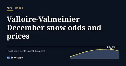
Valloire-Valmeinier offers 131 km of runs and a 98 % chance of 30 cm of snow at mid-mountain by mid-December.