 SnowScope
Pyrenees snow depth today: Estació d'esquí Port del Comte leads with 29 cm (7 November)
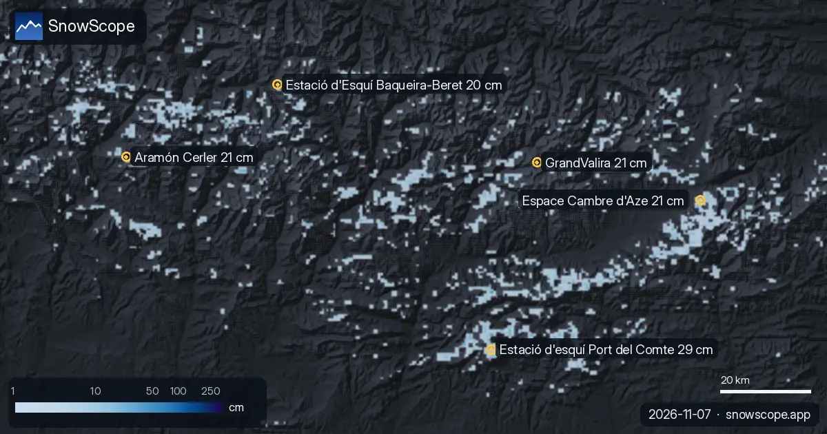
Estació d'esquí Port del Comte (Spain) has the deepest snow in the Pyrenees today, with about 29 cm on its upper slopes. Aramón Cerler follows with 21 cm, then Espace Cambre d'Aze with 21 cm. Our snow model shows 1,650 km² of snow-covered ground in the Pyrenees today, with snow at 37 of 53 resorts.
See the live snow forecast for Estació d'esquí Port del Comte in the SnowScope appSnow depth, powder alerts and the 3D map, free.
Today's snow
The snow cover shrank from 2,380 km² on 5 November to 1,650 km² today, and our forecast gives 720 km² on 10 November.
| Resort | Snow depth | New snow, 72 h | Coming, next days | Top |
|---|---|---|---|---|
| Estació d'esquí Port del Comte | 29 cm | 2 cm | 0 cm | 2,122 m |
| Aramón Cerler | 21 cm | 2 cm | 0 cm | 2,618 m |
| Espace Cambre d'Aze | 21 cm | 1 cm | 0 cm | 2,377 m |
| GrandValira | 21 cm | 1 cm | 0 cm | 2,619 m |
| Estació d'Esquí Baqueira-Beret | 20 cm | 2 cm | 0 cm | 2,600 m |
Against past winters
At about 1,933 m, Estació d'esquí Port del Comte has 16 cm today; a normal 7 November has 0 cm there.
That is more than in 46 of the 46 past winters on this date.
In past winters the best snow at Estació d'esquí Port del Comte usually came mid-January / late January.
An early lead like this matters most for the lower and middle runs, which usually wait until December for this much snow.
Height by height at Estació d'esquí Port del Comte: 1,744 m 0 cm on the ground, 0 cm more in the next 7 days; 1,933 m 0 cm on the ground, 0 cm more in the next 7 days; 2,122 m 1 cm on the ground, 0 cm more in the next 7 days.
Measured on the ground
The Núria (1.971 m) station (1,971 m) measured 8 cm of snow on the ground on 2 November, with 1 cm of new snow in 24 hours. The Boí (2.537 m) station (2,537 m) measured 5 cm of snow on the ground on 2 November. The Das - Aeròdrom station (1,096 m) measured 3 cm of snow on the ground on 2 November.
Resort numbers are model estimates for the upper slopes; station numbers are measurements at one point, on the date shown.
Compared with past winters
This is a good start at Estació d'esquí Port del Comte. At 1,933 m, our model has 16 cm today, deeper than on this date in 46 of the past 46 winters (usual: 0 cm).
At 2,060 m on Aramón Cerler, today's 0 cm is close to normal for the date: deeper than in 16 of the past 46 winters (usual: 1 cm).
This is a good start at Espace Cambre d'Aze. At 2,004 m, our model has 8 cm today, deeper than on this date in 44 of the past 46 winters (usual: 0 cm).
The next days
At Estació d'esquí Port del Comte, the freezing level reaches 3,080 m to 3,720 m on 8 November, above the top of the resort (2,122 m): rain or wet snow is possible on every slope that day.
Forecasts a few days ahead can change: look at the map again the day before you travel.
Tips for skiers
- Snow on the map does not mean a resort is open: check lifts and opening dates on the resort's website.
- Early-season snow is thin. Stay on open, groomed pistes: rocks and grass can hide just under the surface.
- Look for snow high up and on north-facing slopes: they keep it longest, while south-facing slopes lose it first in the sun.
- Before you ski off-piste or go touring, read the official avalanche bulletin (links below).
- Get a powder alert in the SnowScope app to know when Estació d'esquí Port del Comte gets fresh snow.
About these numbers
Resort snow depths are the deepest snow on the resort's upper slopes from the SnowScope snow model (about 1 km, run of 7 November); they are estimates for an area, not a measurement at one point. Station values are measurements on the date shown. Forecasts can change. Always read the official avalanche bulletin before going off-piste.
Official avalanche bulletins: Météo-France – Bulletin d'estimation du risque d'avalanche
Cite this report
For research, teaching or the press: the numbers and charts are free to reuse under CC BY 4.0 with this citation.
SnowScope (2026), Pyrenees snow depth today: Estació d'esquí Port del Comte leads with 29 cm (7 November), https://snowscope.app/blog/en/2026/11/pyrenees-snow-depth-today-7-november-2026.html, accessed 2026-11-07
SnowScope (Atlas Labs). (2026, November 7). Pyrenees snow depth today: Estació d'esquí Port del Comte leads with 29 cm (7 November). SnowScope snow reports. https://snowscope.app/blog/en/2026/11/pyrenees-snow-depth-today-7-november-2026.html
BibTeX
@misc{snowscope2026pyreneessnowdepthtoday7n,
  author       = {{SnowScope (Atlas Labs)}},
  title        = {Pyrenees snow depth today: Estació d'esquí Port del Comte leads with 29 cm (7 November)},
  year         = {2026},
  month        = nov,
  howpublished = {\url{https://snowscope.app/blog/en/2026/11/pyrenees-snow-depth-today-7-november-2026.html}},
  note         = {Published 2026-11-07 10:26 UTC; accessed 2026-11-07}
}· CC BY 4.0 · Methods, data and tools →
Estació d'esquí Port del Comte: snow and temperature by height, this winter vs last (tools) →
Follow Estació d'esquí Port del Comte
Free: a message when fresh snow is coming, and the forecast every morning.

More snow reports

Planning a December trip to Baqueira Beret? See our snow history, ticket prices starting at 70,00 € for a 1-day pass, and how it compares to Astún-Candanchú.
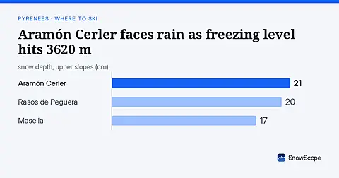
Freezing level reaches 3620 m on Sunday 8 November, above Aramón Cerler's 2618 m top, bringing rain-on-snow risk (forecast from 6 November data).
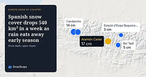
Spain's snow-covered area fell to 310 km² on 16 November. Only 6 of 31 resorts have skiable snow, led by Aramón Cerler at 17 cm.