 SnowScope
Where it snows in the US Northeast in the next 14 days: Sugarbush Resort leads with 9 in
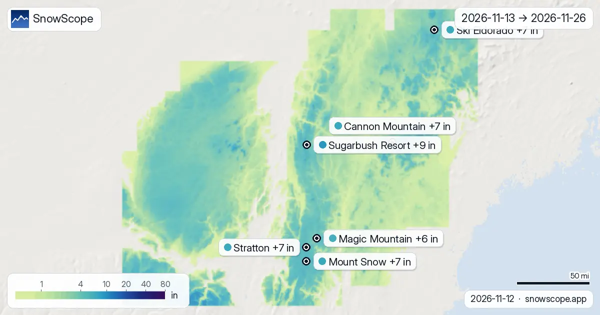
Where will it snow in the US Northeast between 13 November and 26 November, and how much? We asked the two global models that reach two weeks, ECMWF and GFS, kept the middle of their answers for the maps, and note how far apart they are with every figure below. Sugarbush Resort comes out on top with about 9 in (22 cm) of new snow up high (4 in (9 cm)–14 in (35 cm) between the two models); Cannon Mountain is next at 7 in (19 cm). Snow in the mountains is water held back for spring: what falls now feeds rivers and reservoirs later.
See the live snow forecast for Sugarbush Resort in the SnowScope appSnow depth, powder alerts and the 3D map, free.
Resort by resort, the next 14 days
At Sugarbush Resort (United States) the two weeks add up to about 9 in (22 cm) (4 in (9 cm)–14 in (35 cm) depending on the model): 6 in (14 cm) by the end of the first week, then 3 in (8 cm) more. Mark 15 November: that is the biggest day, with 4 in (9 cm).
Cannon Mountain (United States): about 7 in (19 cm) in 14 days (2 in (5 cm)–13 in (34 cm) between the models), 4 in (9 cm) in the first week and 4 in (10 cm) in the second. Mark 26 November: that is the biggest day, with 3 in (7 cm), out of 2 days at 5 cm or more.
At Mount Snow (United States) the two weeks add up to about 7 in (17 cm) (4 in (9 cm)–9 in (24 cm) depending on the model): 4 in (10 cm) by the end of the first week, then 2 in (6 cm) more. The snowiest day is 13 November with 4 in (9 cm); 2 days bring 5 cm or more.
At Ski Eldorado (Canada) the two weeks add up to about 7 in (17 cm) (2 in (6 cm)–11 in (27 cm) depending on the model): 2 in (5 cm) by the end of the first week, then 4 in (11 cm) more. Mark 26 November: that is the biggest day, with 3 in (8 cm).
At Stratton (United States) the two weeks add up to about 7 in (17 cm) (4 in (9 cm)–10 in (25 cm) depending on the model): 4 in (10 cm) by the end of the first week, then 3 in (7 cm) more. Mark 13 November: that is the biggest day, with 3 in (8 cm), out of 2 days at 5 cm or more.
At Magic Mountain (United States) the two weeks add up to about 6 in (15 cm) (3 in (8 cm)–8 in (21 cm) depending on the model): 4 in (9 cm) by the end of the first week, then 2 in (5 cm) more. The snowiest day is 13 November with 3 in (8 cm); 2 days bring 5 cm or more.
| Resort | Snow depth | New snow, 72 h | Coming, next days | Top |
|---|---|---|---|---|
| Sugarbush Resort | 1 in (2 cm) | 2 in (5 cm) | 4 in (10 cm) | 4,062 ft (1,238 m) |
| Cannon Mountain | 0 in (0 cm) | 2 in (5 cm) | 4 in (9 cm) | 4,039 ft (1,231 m) |
| Mount Snow | 1 in (3 cm) | 2 in (4 cm) | 4 in (11 cm) | 3,586 ft (1,093 m) |
| Ski Eldorado | 0 in (0 cm) | 1 in (3 cm) | 2 in (4 cm) | 2,917 ft (889 m) |
| Stratton | 3 in (7 cm) | 3 in (8 cm) | 5 in (12 cm) | 3,881 ft (1,183 m) |
| Magic Mountain | 0 in (0 cm) | 1 in (3 cm) | 4 in (10 cm) | 2,851 ft (869 m) |
New snow by height
Go up and the numbers change. Over the region's terrain, the two-week totals by height are: between 3,281 ft (1,000 m) and 4,921 ft (1,500 m): typically 6 in (15 cm), the snowiest quarter of that band 7 in (18 cm) or more.
The days to watch
The days to circle, counted over the 104 resorts we follow in the US Northeast: Friday 13 November (18 of 104 resorts at 5 cm or more, up to 4 in (9 cm) at Mount Snow) and Wednesday 25 November (12 of 104 resorts at 5 cm or more, up to 2 in (6 cm) at Mount Snow).
First week against second week
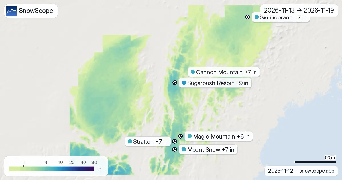
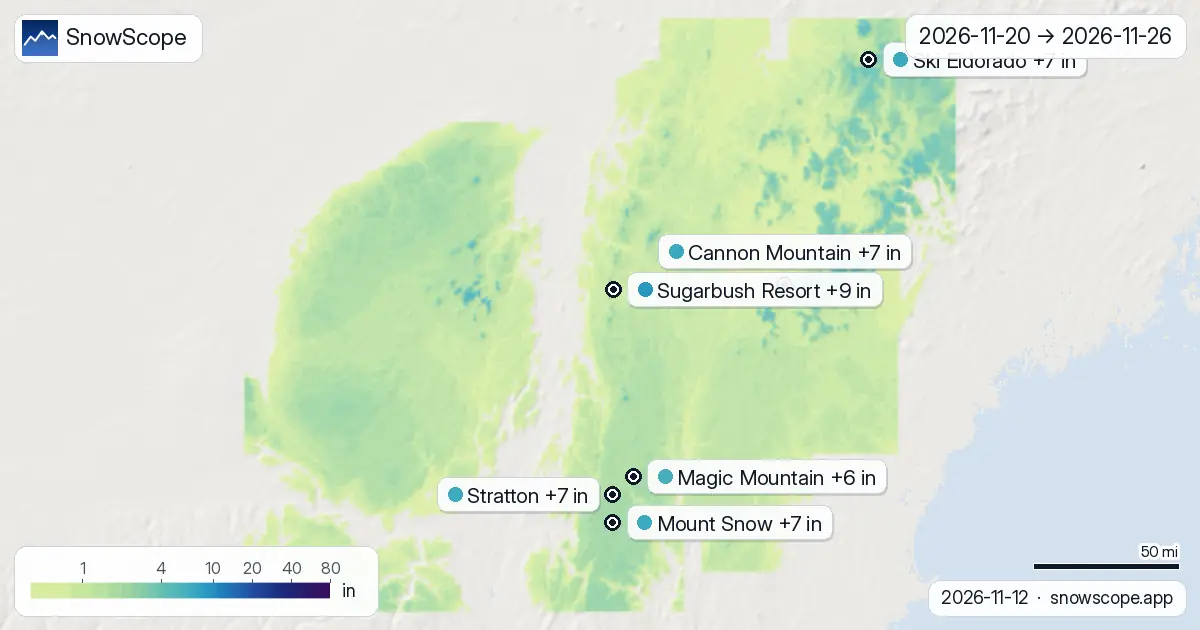
Split by week, the first one (13 November to 19 November) carries 53 % of the two weeks' snow across the region; the second (20 November to 26 November) carries the rest.
Front-loaded: Sugarbush Resort, Mount Snow, Stratton and Magic Mountain get most of their snow in the first week.
Later: at Cannon Mountain and Ski Eldorado the second week brings more than the first.
On the map, about 397 sq mi (1,027 km²) of mountain terrain get 20 cm or more over the two weeks.
How to read the maps
What you are looking at: new snow expected on the real terrain of the region, summed over the two weeks on the first map and over each week on the two others. The colour scale runs from a trace to very large totals; each pin is one resort's upper mountain.
How much to trust it: the near days a lot, the far days a little. The range after each number is the gap between the two models; a small gap is a confident forecast, a wide one a question mark. Come back tomorrow for the next set of maps.
Tips for skiers
- Snow that falls on a thin base needs a few days to ski well: look at the depth maps too before you drive.
- A forecast 0 °C level can be off by several hundred metres; check the map again the day before you go.
- Before any off-piste or touring day, read the official avalanche bulletin (links below).
- Snow on the map does not mean a resort is open: check lifts and dates on the resort's website.
About these numbers
Resort snow depths are the deepest snow on the resort's upper slopes from the SnowScope snow model (about 1 km, run of 12 November); they are estimates for an area, not a measurement at one point. Station values are measurements on the date shown. Forecasts can change. Always read the official avalanche bulletin before going off-piste.
Official avalanche bulletins: Mount Washington Avalanche Center
Cite this report
For research, teaching or the press: the numbers and charts are free to reuse under CC BY 4.0 with this citation.
SnowScope (2026), Where it snows in the US Northeast in the next 14 days: Sugarbush Resort leads with 9 in, https://snowscope.app/blog/en/2026/11/us-northeast-2-week-snow-forecast-maps-12-november-2026.html, accessed 2026-11-12
SnowScope (Atlas Labs). (2026, November 12). Where it snows in the US Northeast in the next 14 days: Sugarbush Resort leads with 9 in. SnowScope snow reports. https://snowscope.app/blog/en/2026/11/us-northeast-2-week-snow-forecast-maps-12-november-2026.html
BibTeX
@misc{snowscope2026usnortheast2weeksnowfore,
  author       = {{SnowScope (Atlas Labs)}},
  title        = {Where it snows in the US Northeast in the next 14 days: Sugarbush Resort leads with 9 in},
  year         = {2026},
  month        = nov,
  howpublished = {\url{https://snowscope.app/blog/en/2026/11/us-northeast-2-week-snow-forecast-maps-12-november-2026.html}},
  note         = {Published 2026-11-12 18:27 UTC; accessed 2026-11-12}
}· CC BY 4.0 · Methods, data and tools →
Sugarbush Resort: snow and temperature by height, this winter vs last (tools) →
Follow Sugarbush Resort
Free: a message when fresh snow is coming, and the forecast every morning.

More snow reports

Northeast forecast made 10 November: 10 in (25 cm) of new snow arriving through 13 November will transform snow cover from 1 resort to 62.
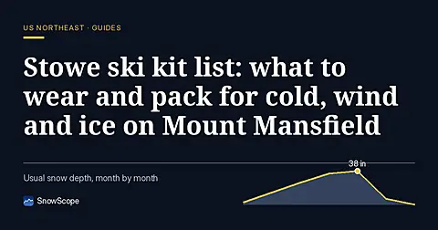
A practical kit list for Stowe, Vermont: layers, face cover, goggles, sharp edges and hand warmers, tied to the snow of 46 past winters on Mount Mansfield.
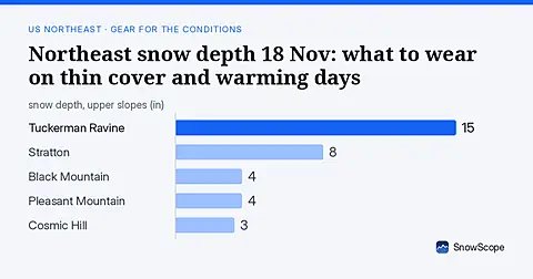
Only 16 US Northeast resorts have skiable snow on 18 Nov. Thin cover and rain-crust risk mean careful gear choices. Forecasts for 19-21 Nov show no new snow.