 SnowScope
Alps freezing level: 0 °C from 1,330 m to 3,210 m, snow line up to 2,900 m (21 November)
The 0 °C level in the Alps, next days: 1,330 m to 3,210 m. Warmest hours: snow line about 300 m lower, up to 2,900 m at La Grave on Sunday 22 November. The snow line is a forecast of a forecast: it follows the freezing level, which can move by hundreds of metres.
See the live snow forecast for La Grave in the SnowScope appSnow depth, powder alerts and the 3D map, free.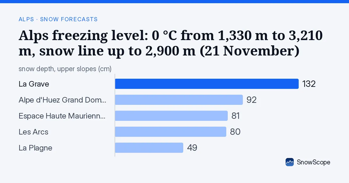
The 0 °C level, daily
The 0 °C level at the resorts below, from the coldest to the warmest hour of each day: Saturday 21 November: from 2,000 m to 2,990 m. Sunday 22 November: from 1,860 m to 3,210 m. Monday 23 November: from 1,340 m to 3,210 m. Tuesday 24 November: from 1,330 m to 2,480 m.
| Resort | Snow depth | New snow, 72 h | Coming, next days | Top |
|---|---|---|---|---|
| La Grave | 132 cm | 92 cm | 90 cm | 3,543 m |
| Alpe d'Huez Grand Domaine | 92 cm | 84 cm | 89 cm | 3,306 m |
| Les Arcs | 80 cm | 102 cm | 74 cm | 3,205 m |
| La Plagne | 49 cm | 91 cm | 73 cm | 3,058 m |
| Espace Haute Maurienne Vanoise | 81 cm | 62 cm | 47 cm | 2,948 m |
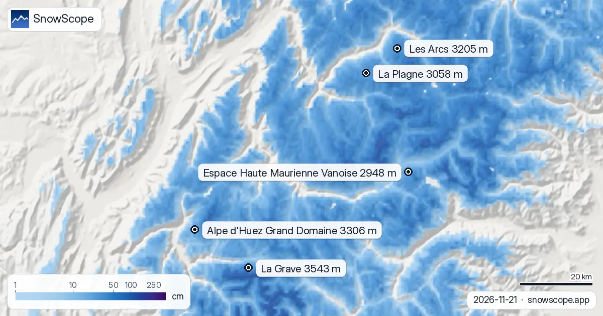
Snow line by resort
La Grave (base 3,196 m, top 3,543 m): snow line about 2,900 m on 22 November, below the base. Snow everywhere.
Alpe d'Huez Grand Domaine, base 1,124 m, top 3,306 m: snow line near 2,500 m on 21 November, splitting the resort: snow up high, wet lower down.
Les Arcs (base 1,222 m, top 3,205 m): snow line about 2,400 m on 21 November, mid-mountain. Snow above, rain or wet snow below.
La Plagne, base 1,217 m, top 3,058 m: snow line near 2,400 m on 21 November, splitting the resort: snow up high, wet lower down.
Espace Haute Maurienne Vanoise (base 1,306 m, top 2,948 m): snow line about 2,400 m on 21 November, mid-mountain. Snow above, rain or wet snow below.
Rain-on-snow risk
Alpe d'Huez Grand Domaine: about 92 cm on the upper slopes, snow line above mid-mountain on 22 November. Rain on snow means heavy and wet first, icy after the refreeze.
Risk flag at Les Arcs: about 80 cm up high and a snow line above mid-mountain on 22 November; rain would make the snow wet, then icy.
La Plagne: about 49 cm on the upper slopes, snow line above mid-mountain on 22 November. Rain on snow means heavy and wet first, icy after the refreeze.
The forecast gives Andermatt (2,963 m) 64 mm of precipitation, with the snow line near 1,170 m during the wet hours.
Lugano (300 m): 44 mm forecast, snow line near 950 m while it falls.
The 0 °C level and the snow line, briefly
Air cools with height, as a rule. Below the 0 °C level flakes begin to melt; melting is slow, so rain starts only some 300 m lower. That is the snow line. Dry air cools the snow by evaporation and pushes the line lower still.
Tips for skiers
- Warm air softens the snow by midday, so ski high and on north-facing slopes early.
- The 0 °C level is a forecast and can move by several hundred metres, which changes where rain turns to snow: check the map again the day before you go.
- Before any off-piste or touring day, read the official avalanche bulletin (links below).
- Snow on the map does not mean a resort is open: check lifts and dates on the resort's website.
About these numbers
Resort snow depths are the deepest snow on the resort's upper slopes from the SnowScope snow model (about 1 km, run of 21 November); they are estimates for an area, not a measurement at one point. Station values are measurements on the date shown. Forecasts can change. Always read the official avalanche bulletin before going off-piste.
Official avalanche bulletins: EAWS (Alps)
Cite this report
For research, teaching or the press: the numbers and charts are free to reuse under CC BY 4.0 with this citation.
SnowScope (2026), Alps freezing level: 0 °C from 1,330 m to 3,210 m, snow line up to 2,900 m (21 November), https://snowscope.app/blog/en/2026/11/alps-freezing-level-snow-line-21-november-2026.html, accessed 2026-11-21
SnowScope (Atlas Labs). (2026, November 21). Alps freezing level: 0 °C from 1,330 m to 3,210 m, snow line up to 2,900 m (21 November). SnowScope snow reports. https://snowscope.app/blog/en/2026/11/alps-freezing-level-snow-line-21-november-2026.html
BibTeX
@misc{snowscope2026alpsfreezinglevelsnowlin,
  author       = {{SnowScope (Atlas Labs)}},
  title        = {Alps freezing level: 0 °C from 1,330 m to 3,210 m, snow line up to 2,900 m (21 November)},
  year         = {2026},
  month        = nov,
  howpublished = {\url{https://snowscope.app/blog/en/2026/11/alps-freezing-level-snow-line-21-november-2026.html}},
  note         = {Published 2026-11-21 12:33 UTC; accessed 2026-11-21}
}· CC BY 4.0 · Methods, data and tools →
La Grave: snow and temperature by height, this winter vs last (tools) →
Follow La Grave
Free: a message when fresh snow is coming, and the forecast every morning.

More snow reports
Alpe d'Huez faces the sun. How to plan a day by the clock and by height, with the snow of 46 past winters from the low villages to Pic Blanc.
96 cm of new snow forecast for Les Arcs over the next three days, with today bringing the heaviest falls; model run November 16.

Alpine day passes from 36 EUR: nine resorts compared by price, kilometres of runs and the snow they usually hold, to find the best day of skiing for your money.