 SnowScope
Snow depth in the Alps compared: Pfelders ahead with 133 cm (13 November)
The snow-covered area has grown from 39,090 km² on 11 November to 76,100 km² today, and our forecast gives 57,910 km² on 16 November: more ground is storing water as snow. Pfelders has the deepest snowpack in the Alps today, about 133 cm up high, followed by Monterosa Ski with 108 cm and Saint-Luc with 98 cm. Our model spreads today's snow over 76,100 km² in the Alps, reaching 829 of 1,179 resorts. Snow depth is only half the story: dense, older snow holds more water than the same depth of new snow.
See the live snow forecast for Pfelders in the SnowScope appSnow depth, powder alerts and the 3D map, free.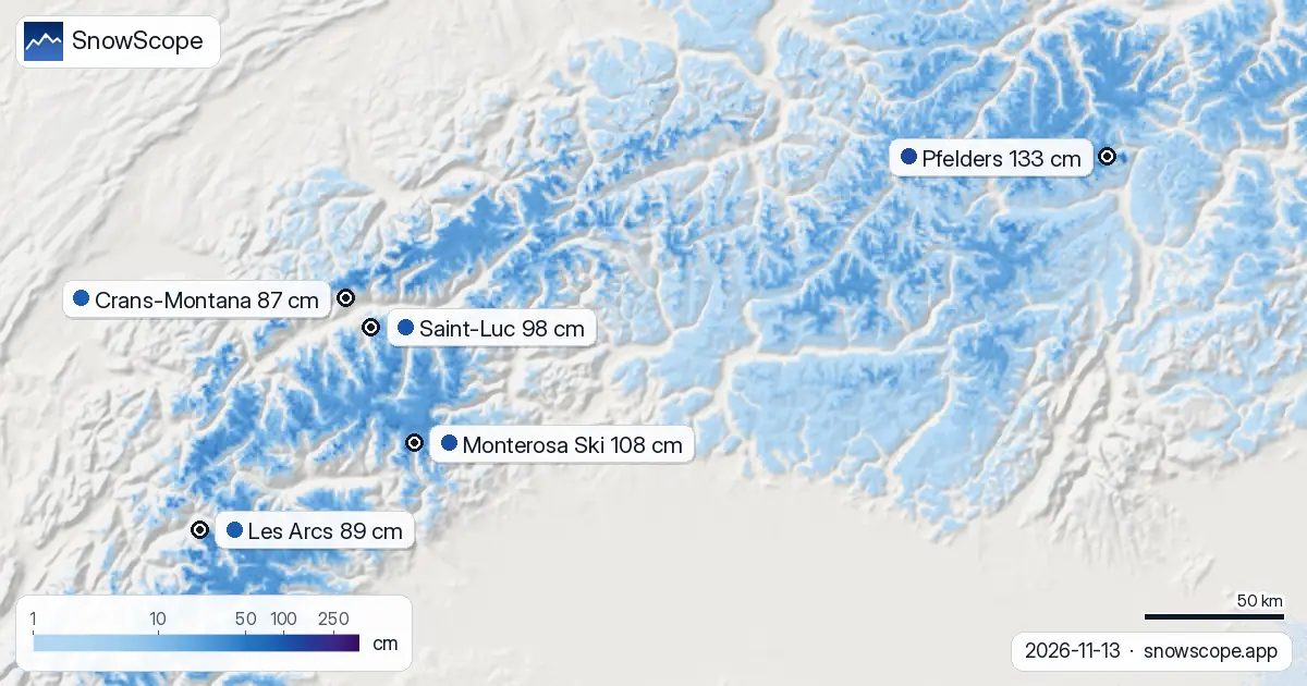
The snow store against past winters
At Monterosa Ski (2,118 m) the season has not begun: no snow today against a usual 12 cm, a start as dry as only 2 of the past 46 winters.
At 2,327 m on Saint-Luc the snow store is behind: 6 cm today against a usual 21 cm. On 13 November, only 8 of the past 46 winters held less.
| Resort | Snow depth | New snow, 72 h | Coming, next days | Top |
|---|---|---|---|---|
| Pfelders | 133 cm | 19 cm | 3 cm | 2,500 m |
| Monterosa Ski | 108 cm | 24 cm | 3 cm | 3,030 m |
| Saint-Luc | 98 cm | 20 cm | 3 cm | 2,973 m |
| Les Arcs | 89 cm | 28 cm | 12 cm | 3,205 m |
| Crans-Montana | 87 cm | 21 cm | 6 cm | 2,872 m |
Far ahead of the rest
Pfelders has 133 cm on its upper slopes, well ahead of Monterosa Ski with 108 cm.
At about 2,050 m, Pfelders has 21 cm today; a normal 13 November has 19 cm there.
Only one winter in ten has more than 41 cm on this date.
A week ago the same spot had 13 cm.
In past winters the best snow at Pfelders usually came late February / early March.
Day by day at Pfelders: Friday 13 November 3 cm; Sunday 15 November 1 cm; Monday 16 November 2 cm.
Height by height at Pfelders: 1,600 m 0 cm on the ground, 9 cm more in the next 7 days; 2,050 m 0 cm on the ground, 15 cm more in the next 7 days; 2,500 m 5 cm on the ground, 18 cm more in the next 7 days.
Today's snow store
Since 11 November the snow cover went up from 39,090 km² to 76,100 km²; on 16 November the forecast gives 57,910 km².
The next days in the forecast
Until 16 November, the forecast adds 12 cm at Les Arcs, 6 cm at Crans-Montana and 3 cm at Pfelders; amounts several days out can still change.
At Pfelders the freezing level reaches 1,870 m to 2,240 m on 14 November: lower down the snow may turn wet, higher up it stays cold.
Forecasts a few days ahead can change: look at the map again the day before you travel.
Measured snow
The Weißseespitze station (3,499 m) reported a snow depth of 264 cm on 13 November. Measured, not modelled: the Sonnblick station (3,109 m) recorded 55 cm of snow on the ground on 13 November, with 23 cm of new snow in 24 hours. The Lanzada Passo Marinelli station (3,032 m) reported a snow depth of 52 cm on 13 November, 19 cm of it from the last 24 hours.
A note on measurement: resort values are modelled for the upper slopes, station values are measured at one place on the date given, and both carry some uncertainty.
Tips for skiers
- Snow on the map does not mean a resort is open: check lifts and opening dates on the resort's website.
- Early-season snow is thin. Stay on open, groomed pistes: rocks and grass can hide just under the surface.
- Shade protects the snowpack. High, north-facing slopes get less sun, so their snow lasts longer than on the south side.
- Before you ski off-piste or go touring, read the official avalanche bulletin (links below).
- Get a powder alert in the SnowScope app to know when Pfelders gets fresh snow.
About these numbers
Resort snow depths are the deepest snow on the resort's upper slopes from the SnowScope snow model (about 1 km, run of 13 November); they are estimates for an area, not a measurement at one point. Station values are measurements on the date shown. Forecasts can change. Always read the official avalanche bulletin before going off-piste.
Official avalanche bulletins: WSL-SLF
Cite this report
For research, teaching or the press: the numbers and charts are free to reuse under CC BY 4.0 with this citation.
SnowScope (2026), Snow depth in the Alps compared: Pfelders ahead with 133 cm (13 November), https://snowscope.app/blog/en/2026/11/alps-pfelders-snow-depth-today-13-november-2026.html, accessed 2026-11-13
SnowScope (Atlas Labs). (2026, November 13). Snow depth in the Alps compared: Pfelders ahead with 133 cm (13 November). SnowScope snow reports. https://snowscope.app/blog/en/2026/11/alps-pfelders-snow-depth-today-13-november-2026.html
BibTeX
@misc{snowscope2026alpspfelderssnowdepthtod,
  author       = {{SnowScope (Atlas Labs)}},
  title        = {Snow depth in the Alps compared: Pfelders ahead with 133 cm (13 November)},
  year         = {2026},
  month        = nov,
  howpublished = {\url{https://snowscope.app/blog/en/2026/11/alps-pfelders-snow-depth-today-13-november-2026.html}},
  note         = {Published 2026-11-13 13:02 UTC; accessed 2026-11-13}
}· CC BY 4.0 · Methods, data and tools →
Pfelders: snow and temperature by height, this winter vs last (tools) →
Follow Pfelders
Free: a message when fresh snow is coming, and the forecast every morning.

More snow reports
Is Verbier good for beginners? When is the snow best? How do you get there? Answers from the 4 Vallées and 46 past winters of snow data.
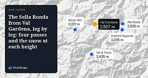
A walk-through of the Sella Ronda from Sëlva in Val Gardena: Gardena, Campolongo, Pordoi and Sella passes in order, with our snow history of 46 past winters.
Chantarella, Marguns, Piz Nair, White Turf: the words you hear in St. Moritz, explained, and what 46 past winters of our snow history say about each height of Corviglia.