 SnowScope
Luleå snow depth: no airport reading, 3 to 7 cm all around (13 November 2026)
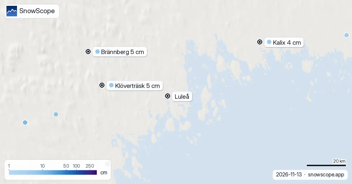
Luleå is most likely white this Friday, but the city's own snow stake did not tell us. The station at Kallax airport, which had bare ground on Thursday, sent no snow-depth reading today. The ring of stations around the city did, and every one of them measured its first snow since at least late October.
See the live snow forecast for Luleå in the SnowScope appSnow depth, powder alerts and the 3D map, free.
The ring around the city
Klöverträsk, 35 km to the west, measured 5 cm. Brännberg, inland, 5 cm. Piteå, down the coast, 3 cm. Kalix, up the coast, 4 cm. Klockarträsk, at 148 m, 7 cm, and Veniksel 3 cm. Those that reported on Thursday all had bare ground.
With snow on all sides and the same storm overhead, it is a fair bet that Luleå itself has a few centimetres too, but that is our reading of the neighbours, not a measurement in the city.
Normal for mid-November
Our snow history for Luleå covers 46 past winters. On 13 November there was snow on the ground in 31 of them, and the middle value is 2 cm, with 6 cm or more in one winter of four. So 3 to 7 cm around the city is a normal-to-good start. Half the winters had their first lasting cover by 2 November.
By 1 December Luleå usually has about 7 cm, by mid-December about 11 cm and by mid-January about 27 cm. On this date in the last five winters: 1 cm, bare, 9 cm, bare and 3 cm.
The weekend
Friday itself brings about 3 cm more snow at just below zero. Saturday is colder, down to around -8 °C, with only a light dusting. Sunday adds 1 to 2 cm and turns milder in the afternoon, up to about 3 °C. On Monday rain, 5 to 8 mm, at a few degrees above zero, will test the cover.
Tips for skiers
- Saturday, cold and white, is the day for the first walk on the snowy paths along the shore.
- The bay and the rivers are not frozen: stay off any ice, however white the shore looks.
- Monday's rain on fresh snow means ice on Tuesday morning: ice grips by the door.
More maps (external sites)
References and credits
- SMHI, open meteorological observations (snow depth, daily) www.smhi.se/data/meteorologi/ladda-ner-meteorologiska-observationer
- Open-Meteo, weather forecast data (ECMWF and ICON models) open-meteo.com/
About these numbers
Snow depth today: measured at weather stations on the morning of 13 November 2026 (SMHI); a station reports the snow on its own small plot, so a few kilometres away and a hundred metres higher the ground can look different. Usual depth for the date: SnowScope snow history, 46 past winters (1980-81 to 2025-26), a model of the past at the city's height, not a station record. Weekend: two weather models (ECMWF IFS and DWD ICON, read through Open-Meteo), given as a range. Places and rules: the official pages listed below.
Cite this report
For research, teaching or the press: the numbers and charts are free to reuse under CC BY 4.0 with this citation.
SnowScope (2026), Luleå snow depth: no airport reading, 3 to 7 cm all around (13 November 2026), https://snowscope.app/blog/en/2026/11/lulea-snow-depth-13-november-2026.html, accessed 2026-11-13
SnowScope (Atlas Labs). (2026, November 13). Luleå snow depth: no airport reading, 3 to 7 cm all around (13 November 2026). SnowScope snow reports. https://snowscope.app/blog/en/2026/11/lulea-snow-depth-13-november-2026.html
BibTeX
@misc{snowscope2026luleasnowdepth13november,
  author       = {{SnowScope (Atlas Labs)}},
  title        = {Luleå snow depth: no airport reading, 3 to 7 cm all around (13 November 2026)},
  year         = {2026},
  month        = nov,
  howpublished = {\url{https://snowscope.app/blog/en/2026/11/lulea-snow-depth-13-november-2026.html}},
  note         = {Published 2026-11-14 13:29 UTC; accessed 2026-11-13}
}· CC BY 4.0 · Methods, data and tools →
Follow Luleå
Free: a message when fresh snow is coming, and the forecast every morning.

More snow reports
Skiing Lake Louise early in the season: why it starts early, what November and December snow usually looks like in 46 past winters, and how to ski thin early cover.
Baqueira-Beret sits in the Val d'Aran, on the Atlantic side of the Pyrenees. What that means for its snow, tested with 46 past winters against La Molina, and when to go.
Banff Sunshine Village month by month: about 100 cm at mid-mountain in a usual March over 46 past winters, April deepest near the top, and a season into late May.