 SnowScope
Global warming and the decline of snow in the Pyrenees: what 46 winters show
Is there really less snow in the Pyrenees than a generation ago? In our record of 46 winters, from 1980-81 to 2025-26, all 120 points we studied at 40 ski resorts have fewer days with snow on the ground than at the start, and the largest loss is below 1,500 m.
See the live snow forecast for Pyrenees in the SnowScope appSnow depth, powder alerts and the 3D map, free.
What we looked at, and what we did not
Our snow history is a model of past winters: ERA5-Land, a global reconstruction of the weather, corrected for the height of each resort. We read it at the base, the middle and the top of 40 Pyrenean resorts, from 1,103 m to 2,747 m, and counted for every winter the days with at least 5 cm of snow on the ground and the deepest snow of the season. These are estimates for an area, not station measurements, and a model can miss local effects such as wind drift or snowmaking.
To describe change we compared the middle (median) of the first 15 winters with the last 15, and we drew a robust trend line through all 46 winters. A trend counts as clear only when a standard statistical test (Mann-Kendall) gives less than a 5 % chance that it is random.
Fewer snow days at every height
Below 1,500 m, the middle point had 116 snow days a winter in the first 15 winters and 85 in the last 15, a drop of 26 %. Between 1,500 and 2,000 m the drop is 12 % (138 to 122 days), between 2,000 and 2,500 m it is 9 % (164 to 150 days), and above 2,500 m it is 11 % (177 to 157 days).
Across all points the typical trend is a loss of about 6.3 snow days per decade. Every one of the 120 points shows a decline, but it passes the significance test at only 37 % of them: from one winter to the next, Pyrenean snow swings so much that a clear signal needs a long record.
The deepest snow of winter: a smaller, less certain loss
The deepest snow of each winter has gone down too, but less: by about 2.1 cm per decade at the middle point, and at 98 % of the points. Between 2,000 and 2,500 m the usual season peak went from 106 cm to 98 cm; above 2,500 m from 145 cm to 133 cm.
None of these peak-depth trends passes the significance test at any point. Big winters still happen: the season length suffers first, the depth of a good winter much less.
Why the low slopes lose the most
Snow needs two things: precipitation and air cold enough to keep it frozen. Near 1,500 m, many winter storms in the Pyrenees fall close to the rain-snow limit. A little warming moves that limit up the slope, so the same storm brings rain instead of snow, and the snow that does fall melts sooner between storms. Higher up, the air stays below freezing for most of the winter, so warming shortens the season at its start and end rather than every week.
That is why our loss of snow days is largest below 1,500 m (26 %) and smaller higher up (9 to 12 %). The season peak changes less, because it depends mostly on how much snow the big storms bring, and that varies a lot from year to year.
How sure can we be?
Three cautions. Our record is a model, not a ruler in the snow; it reproduces the broad picture but not every slope. Forty-six winters is long for a ski resort and short for the climate. And the Pyrenees are a mosaic: Atlantic west, Mediterranean east, French north face and Spanish south face. A range-wide median hides big local differences, as the research below also finds.
Big swings from one winter to the next
The record is not a smooth slide. The poorest winter in our series is 1989-90, with a median of 60 snow days across the points, followed by 2023-24 (86 days) and 2022-23 (96 days). The richest were 2008-09 (200 days), 1980-81 (194 days) and 2012-13 (188 days).
Two of the three poorest winters are recent, but one winter says little about the climate. The chart shows each winter (thin lines) and a five-winter average (thick lines) for each height band.
What the research says
Our model numbers agree with the scientific literature. López-Moreno and colleagues simulated the snowpack of the whole range from 1958 to 2017, at 1,500 m and 2,100 m. Snow cover duration and average depth decreased, significantly at 2,100 m; the western French Pyrenees lost the most, while some eastern massifs showed no decrease at 1,500 m. Most of the decline was not linked to changes in weather patterns, which points to warming, sharp since 1955, as a major driver. When the authors started their trends in 1980, they were no longer significant: about 40 winters is a short window for a range with such variable snow.
The ice tells the same story with less noise. According to the Pyrenean Climate Change Observatory (OPCC), the glaciers of the Pyrenees have lost 94.5 % of their area since 1850, and 51 glaciers have disappeared since 1985.
What it means for skiing
For the coming decades, Spandre and colleagues modelled 175 ski resorts in France, Spain and Andorra. With snowmaking, the height at which a resort can count on enough snow is projected to rise by 400 to 600 m in the Pyrenees by 2030-2050, against 200 to 300 m in the Alps. Further ahead, the result depends on how much greenhouse gas the world emits.
In practice, the high resorts and north-facing slopes keep their snow longest, and low resorts will see good and poor winters side by side. Each resort page on SnowScope shows how this winter compares with the 46 before it.
Tips for skiers
- For early-season trips, choose the highest resorts of the range and keep plans flexible below 1,500 m.
- Check the live snow map and the resort's past-winters chart before you book.
- In a poor winter, ski north-facing slopes and the upper lifts, where the snow lasts longest.
- Off-piste, always read the official avalanche bulletin of the French, Spanish, Catalan or Andorran service.
References and credits
- López-Moreno, J. I., Soubeyroux, J. M., Gascoin, S., Alonso-González, E. et al. (2020). Long-term trends (1958-2017) in snow cover duration and depth in the Pyrenees. International Journal of Climatology 40, 6122-6136. doi.org/10.1002/joc.6571
- Spandre, P., François, H., Verfaillie, D., Pons, M. et al. (2019). Winter tourism under climate change in the Pyrenees and the French Alps: relevance of snowmaking as a technical adaptation. The Cryosphere 13, 1325-1347. doi.org/10.5194/tc-13-1325-2019
- Pyrenean Climate Change Observatory (OPCC), Pyrenean Cryosphere: glacier area and glaciers lost (retrieved 7 November 2026). criosfera.opcc-ctp.org/en/
- Muñoz-Sabater, J. et al. (2021). ERA5-Land: a state-of-the-art global reanalysis dataset for land applications. Earth System Science Data 13, 4349-4383. doi.org/10.5194/essd-13-4349-2021
About these numbers
Our numbers: the SnowScope snow history, 46 past winters (1980-81 to 2025-26) read at the base, middle and top of each resort: ERA5-Land, a global reconstruction of past weather, corrected for height. It is a model of past winters, an estimate for an area, not station measurements. Snow day = at least 5 cm on the ground. Change = median of the last 15 winters against the first 15; trend = robust (Theil-Sen) line through all 46 winters, 'clear' when the Mann-Kendall test gives p < 0.05. Research findings: the sources below.
Cite this report
For research, teaching or the press: the numbers and charts are free to reuse under CC BY 4.0 with this citation.
SnowScope (2026), Global warming and the decline of snow in the Pyrenees: what 46 winters show, https://snowscope.app/blog/en/2026/11/pyrenees-snow-decline-global-warming-46-winters.html, accessed 2026-11-08
SnowScope (Atlas Labs). (2026, November 8). Global warming and the decline of snow in the Pyrenees: what 46 winters show. SnowScope snow reports. https://snowscope.app/blog/en/2026/11/pyrenees-snow-decline-global-warming-46-winters.html
BibTeX
@misc{snowscope2026pyreneessnowdeclinegloba,
  author       = {{SnowScope (Atlas Labs)}},
  title        = {Global warming and the decline of snow in the Pyrenees: what 46 winters show},
  year         = {2026},
  month        = nov,
  howpublished = {\url{https://snowscope.app/blog/en/2026/11/pyrenees-snow-decline-global-warming-46-winters.html}},
  note         = {Published 2026-11-08 21:22 UTC; accessed 2026-11-08}
}· CC BY 4.0 · Methods, data and tools →
Follow Pyrenees
Free: a message when fresh snow is coming, and the forecast every morning.

More snow reports
Baqueira-Beret sits in the Val d'Aran, on the Atlantic side of the Pyrenees. What that means for its snow, tested with 46 past winters against La Molina, and when to go.
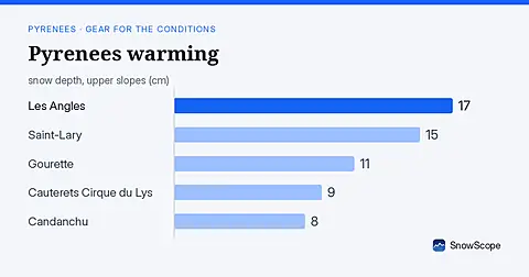
Rain forecast as freezing level climbs to 4080 m; snow measured on 15 November is thin (under 20 cm) at all major Pyrenees resorts.
For a low-cost December family ski week at Astún-Candanchú, aim for late December when top slopes hold good snow in 67 % of past winters.