 SnowScope
Serre Chevalier next week: a powder top-up of 25–68 cm (snow forecast 23–29 November 2026)
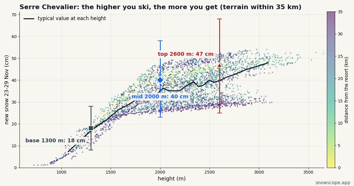
The question for anyone heading to Serre Chevalier next week is simple: how much, and where? Between Monday 23 and Sunday 29 November our forecast puts 47 cm on the upper slopes (25–68 cm), 40 cm around 2000 m and 18 cm at the base, with Wednesday 25 November as the snowiest day.
See the live snow forecast for Serre Chevalier in the SnowScope appSnow depth, powder alerts and the 3D map, free.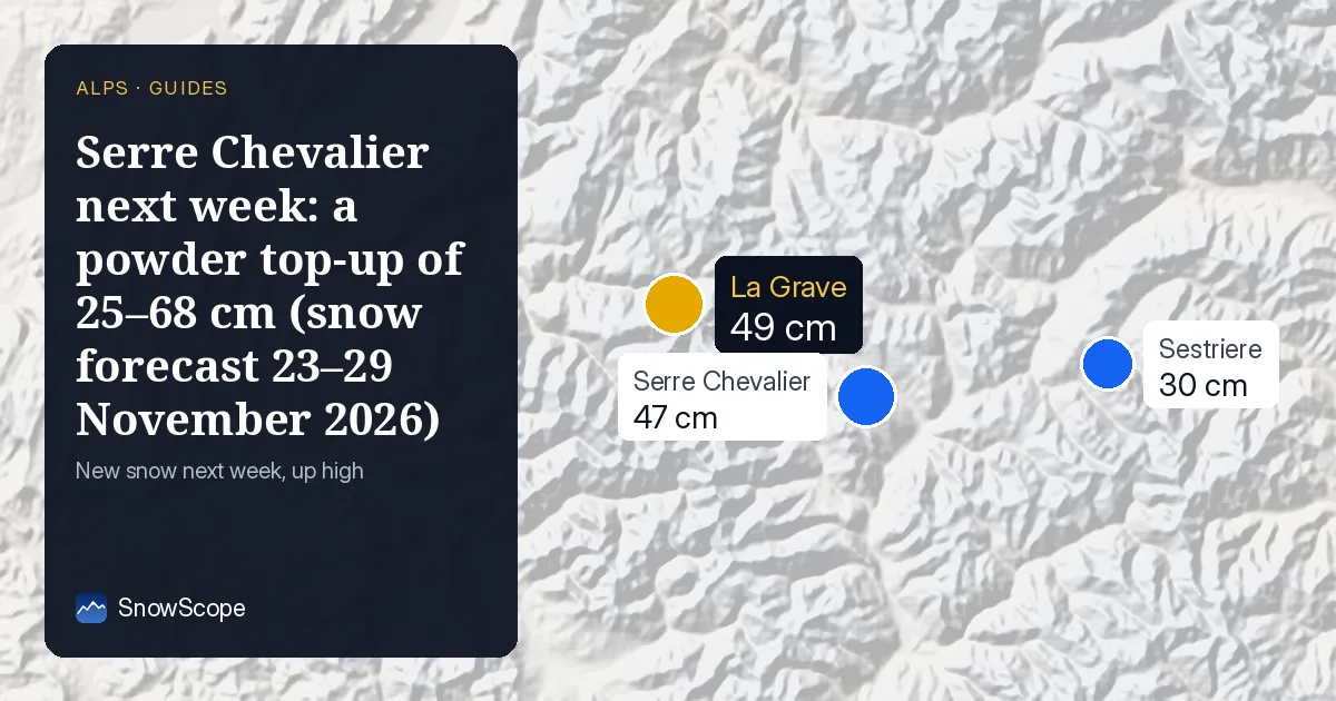
What 17–20 November leaves behind
This week is the heavy one: 62 cm at the top between 17 and 20 November (range 42–83 cm), 0 cm at the base. Next week's snow falls onto that, which matters more than the size of the second round.
The numbers for 23–29 November
Read from the top down: 47 cm near 2600 m, 40 cm near 2000 m, 18 cm near 1300 m. The low-to-high spread is 25–68 cm at the top and 8–28 cm at the base.
Day by day, the upper mountain picks up most of it on Tuesday 24 (8 cm, up to 10), Wednesday 25 (20 cm, up to 26), Thursday 26 (8 cm, up to 13) and Sunday 29 (9 cm, up to 19). Outside those days expect little more than flurries.
Picking your day in Serre Chevalier
If you can pick one day, take the one that follows Wednesday 25 November, when 20 cm (up to 26 cm) has landed on the upper mountain.
The snow lies best on the top lifts above Chantemerle and Le Monêtier. For the softest turns, look to the north-east-facing slopes above Le Monêtier and the larch forest when light is flat. Lower down, the Briançon end of the valley will be the first to suffer if the air turns mild.
Snow or rain at the bottom?
Half-and-half at the bottom: 18 cm near 1300 m is a fair amount, but well short of the top's 47 cm. Mild spells will turn the lowest runs heavy and sticky.
Serre Chevalier's larch woods give the Southern Alps some of their best storm-day skiing.
The range, not just the number
Medium. Our range at the top runs from 25 to 68 cm, so the storm is likely but its size is not settled. Take the middle value as a guide, not a promise.
A forecast seven to thirteen days out is a trend, not a ticket.
Is Serre Chevalier the best bet nearby?
At the top, next week, our forecast gives La Grave (24 km away) 49 cm, Sestriere (28 km away) 30 cm and Les 2 Alpes (33 km away) 47 cm, against 47 cm here.
A few centimetres either way is inside the forecast's own margin, so Serre Chevalier and its neighbours are effectively level.
Tips for skiers
- Off the groomed runs, new snow means new avalanche risk: the French avalanche bulletin (BERA) for the massif is the reference.
- Opening dates are the resort's call; our numbers only say how much snow is coming.
- Ride up for the snow: the base gets 18 cm, the top 47 cm.
More maps (external sites)
About these numbers
Snow numbers: our two-week snow forecast issued on 16 November 2026, read at three heights of the resort (top, mid-mountain, base). Each total is the middle of a range, with a low and a high case. These are estimates for the slopes, not resort measurements, and forecasts move from day to day: check the live map before you go.
Cite this report
For research, teaching or the press: the numbers and charts are free to reuse under CC BY 4.0 with this citation.
SnowScope (2026), Serre Chevalier next week: a powder top-up of 25–68 cm (snow forecast 23–29 November 2026), https://snowscope.app/blog/en/2026/11/serre-chevalier-powder-forecast-next-week-23-29-november-2026.html, accessed 2026-11-16
SnowScope (Atlas Labs). (2026, November 16). Serre Chevalier next week: a powder top-up of 25–68 cm (snow forecast 23–29 November 2026). SnowScope snow reports. https://snowscope.app/blog/en/2026/11/serre-chevalier-powder-forecast-next-week-23-29-november-2026.html
BibTeX
@misc{snowscope2026serrechevalierpowderfore,
  author       = {{SnowScope (Atlas Labs)}},
  title        = {Serre Chevalier next week: a powder top-up of 25–68 cm (snow forecast 23–29 November 2026)},
  year         = {2026},
  month        = nov,
  howpublished = {\url{https://snowscope.app/blog/en/2026/11/serre-chevalier-powder-forecast-next-week-23-29-november-2026.html}},
  note         = {Published 2026-11-16 11:26 UTC; accessed 2026-11-16}
}· CC BY 4.0 · Methods, data and tools →
Serre Chevalier: snow and temperature by height, this winter vs last (tools) →
Follow Serre Chevalier
Free: a message when fresh snow is coming, and the forecast every morning.

More snow reports
Discover the calm slopes of St-Luc Chandolin where mid-mountain snow has reached 30 cm in 98 % of winters during late December.
Puy-Saint-Vincent pairs a 44 EUR adult 1-day pass with solid December snow higher up, compared here with its big neighbour Serre Chevalier.
Pila above Aosta pairs a flat 60.00 EUR day pass with reliable December snow on its upper slopes.