 SnowScope
Orelle tracks the normal 42 cm path as November snow arrives
Orelle sits at 42 cm today, tracking just below the normal depth for this time of year. Over the next 72 hours, the Alps will fill with fresh snow as a system moves in, with Orelle forecast to gain 102 cm across its upper slopes.
See the live snow forecast for Orelle in the SnowScope appSnow depth, powder alerts and the 3D map, free.
Where we are now
Orelle holds 42 cm measured at 2780 m. For mid-November, the typical depth here is 53 cm, so we are running about 20 percent behind the long-term average. A week ago the snowpack was much shallower at just 14 cm, so the mountain has built up steadily. This is still early season snow, thin and patchy in places, so rocks and terrain hazards remain close to the surface on many slopes.
The water stored in the snowpack at Orelle right now is modest by winter standards. November snow is often light and fluffy because cold air has not yet settled in deeply, so the density is low. As December approaches and temperatures drop further, the same amount of precipitation will compress the snowpack more efficiently and store more water in the mountains.
| # | Resort | Region | +24 h | +72 h | Snow line |
|---|---|---|---|---|---|
| 1 | Orelle | Alps · France | 22 cm | 102 cm | 2,500 m |
| 2 | Courmayeur | Alps · Italy | 28 cm | 100 cm | 2,000 m |
| 3 | Balme | Alps · France / Switzerland | 20 cm | 99 cm | 2,000 m |
| 4 | Valmorel | Alps · France | 18 cm | 97 cm | 2,100 m |
| 5 | Les Houches | Alps · France | 25 cm | 96 cm | 2,000 m |
| 6 | Arêches Beaufort | Alps · France | 23 cm | 96 cm | 2,100 m |
| 7 | Evasion Mont Blanc | Alps · France | 23 cm | 93 cm | 2,100 m |
| 8 | Les Arcs | Alps · France | 22 cm | 92 cm | 2,100 m |
| # | Resort | Region | +24 h | +72 h | Snow line |
|---|---|---|---|---|---|
| 1 | China Peak | US West · United States | 3 in (7 cm) | 35 in (88 cm) | 6,600 ft (2,000 m) |
| 2 | Mammoth Mountain | US West · United States | 4 in (9 cm) | 31 in (80 cm) | 6,600 ft (2,000 m) |
| 3 | June Mountain | US West · United States | 4 in (10 cm) | 31 in (78 cm) | 6,900 ft (2,100 m) |
| 4 | Kingvale | US West · United States | 8 in (21 cm) | 30 in (77 cm) | – |
| 5 | Badger Pass | US West · United States | 5 in (12 cm) | 30 in (77 cm) | 5,900 ft (1,800 m) |
| 6 | Boreal | US West · United States | 8 in (20 cm) | 30 in (75 cm) | 5,200 ft (1,600 m) |
| 7 | Kirkwood | US West · United States | 7 in (19 cm) | 30 in (75 cm) | 6,200 ft (1,900 m) |
| 8 | Palisades Tahoe Alpine Meadows | US West · United States | 7 in (19 cm) | 29 in (73 cm) | 5,200 ft (1,600 m) |
| # | Resort | Region | +24 h | +72 h | Snow line |
|---|---|---|---|---|---|
| 1 | Fortress | Western Canada · Canada | 6 cm | 6 cm | 1,400 m |
| 2 | Nakiska | Western Canada · Canada | 6 cm | 6 cm | 1,500 m |
| 3 | WinSport (Canada Olympic Park) | Western Canada · Canada | 6 cm | 6 cm | 800 m |
| 4 | Castle | Western Canada · Canada | 5 cm | 6 cm | 1,200 m |
| 5 | Pass Powderkeg ski | Western Canada · Canada | 5 cm | 6 cm | 1,100 m |
| 6 | Banff Sunshine Village | Western Canada · Canada | 4 cm | 4 cm | 1,400 m |
| 7 | Mt Norquay | Western Canada · Canada | 4 cm | 4 cm | 1,400 m |
| 8 | Wapiti | Western Canada · Canada | 3 cm | 4 cm | 1,400 m |
The forecast fills the gap
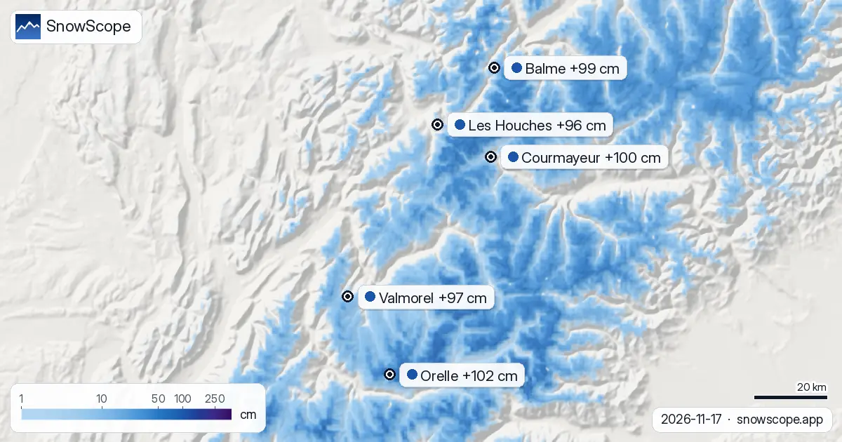
Over the next 24 hours, 22 cm of fresh snow is forecast on Orelle's upper slopes. Within 72 hours, that total rises to 102 cm. This is a large gain by any measure, and it arrives at a time when the snowpack is thinner than usual. The snow line will hover around 2500 m, meaning slopes above that height will receive the most benefit.
Across the Alps, the heaviest accumulation will fall on resorts facing northwest and west-facing slopes where the air mass will be forced upward. Courmayeur in Italy shows the most aggressive forecast among major resorts, with 28 cm in the next day and 100 cm in 72 hours. The systems feeding this snow will push moisture in from the Atlantic and Mediterranean, typical of November weather patterns that set up once the season begins.
Three days reshape the season
If this forecast verifies, the snowpack at Orelle will more than double. That transforms the mountain from marginal early-season coverage into a base that skiers can rely on. The 102 cm gain over 72 hours is not unusual for a strong Alpine system in November, but it arrives at a moment when the existing pack is thin, so the percentage gain is striking.
Balme, Les Houches, Arêches Beaufort, and Evasion Mont Blanc will all see similar heavy falls, each forecast to gain between 93 and 99 cm. The western Alps, where systems enter first, will fill faster than the central valleys. By the end of Wednesday, the character of the season will have shifted from tick-the-box early season to genuinely skiable conditions on the upper mountain.
Water in the system
From a hydrological view, 100 cm of November snow represents a significant recharge to the Alpine reservoir. At typical November densities, 102 cm will store roughly 25 to 30 mm of water equivalent. That water is locked in the high peaks now, insulating reservoir intakes lower down and feeding the spring melt that feeds rivers and towns through summer.
The measurement uncertainty in a forecast of this magnitude is real. Model disagreement is usually smallest three days ahead, but weather systems can still shift speed or intensity. The snow line forecast at 2500 m suggests that lower valleys may see rain mixed in, so the transition zone will be a threshold between wet and white. Check local avalanche bulletins before heading off-piste, since rapid loading on steep slopes raises hazard even when the base below is old and stable.
Beyond the Alps
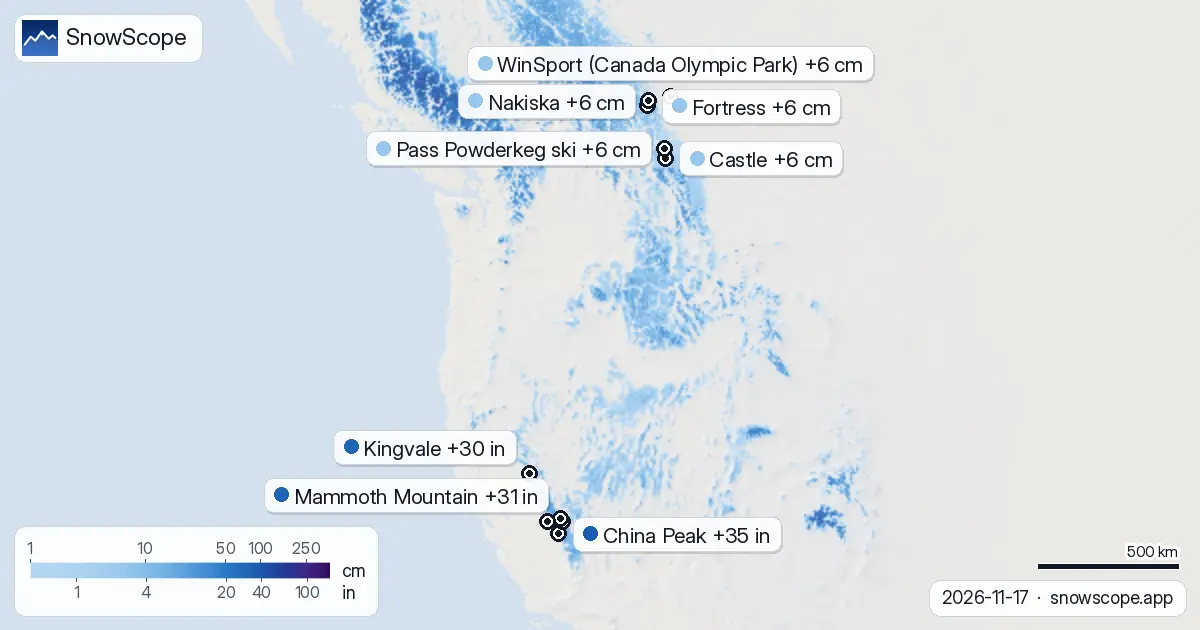
In North America, the picture is drier. China Peak in California's Sierra Nevada leads the continent with 88 cm forecast over 72 hours, but conditions are modest compared to Europe. Mammoth Mountain and June Mountain will see 80 and 78 cm respectively. The snow line sits higher across the US West, around 2000 m, limiting the terrain that benefits. Kingvale will capture the most moisture in the near term with 21 cm in 24 hours.
Western Canada is starved of snow. Fortress and Nakiska each hold 6 cm for the next 72 hours, with little organized precipitation expected. Banff Sunshine Village forecasts only 4 cm, and even the wettest sites will gain barely more than a dusting. The prairies and mountains of western Canada are not in the path of this system; they will have to wait for different weather to arrive.
What to watch
Track the snowfall timing across the Alps. If heavier bands move through Orelle on Tuesday rather than Wednesday, the upper slopes will burden quickly and avalanche risk could spike. The official avalanche bulletin for your area is essential reading before any off-piste travel.
By Thursday morning, the snowpack at Orelle will be transformed. The question then shifts from depth to stability: how well is the new snow bonding to the November base beneath it? That answer will shape the safest lines for the coming days. Use SnowScope to track how the mountains fill in and find which resorts gain the most water and depth in real time.
Tips for skiers
- Stick to marked runs on Tuesday and Wednesday while fresh snow loads the upper slopes. Wait for conditions to stabilize before exploring steeper off-piste terrain.
- The snow line at 2500 m at Orelle means the best coverage will be above that height. Lower slopes may still show patches of ground, especially on south-facing aspects.
- By Thursday, 102 cm of new snow will make for fast, potentially heavy conditions. Use a shovel to test the bond between new and old snow before committing to steep lines.
- Check the official avalanche bulletin for your region before leaving the resort. Early-season loading on a thin base can trigger slabs even on slopes that feel stable.
About these numbers
Resort snow depths are the deepest snow on the resort's upper slopes from the SnowScope snow model (about 1 km, run of 16 November); they are estimates for an area, not a measurement at one point. Station values are measurements on the date shown. Forecasts can change. Always read the official avalanche bulletin before going off-piste.
Official avalanche bulletins: EAWS (Europe) · avalanche.org (US) · Avalanche Canada
Cite this report
For research, teaching or the press: the numbers and charts are free to reuse under CC BY 4.0 with this citation.
SnowScope (2026), Orelle tracks the normal 42 cm path as November snow arrives, https://snowscope.app/blog/en/2026/11/where-most-snow-falls-next-72-hours-17-november-2026.html, accessed 2026-11-17
SnowScope (Atlas Labs). (2026, November 17). Orelle tracks the normal 42 cm path as November snow arrives. SnowScope snow reports. https://snowscope.app/blog/en/2026/11/where-most-snow-falls-next-72-hours-17-november-2026.html
BibTeX
@misc{snowscope2026wheremostsnowfallsnext72,
  author       = {{SnowScope (Atlas Labs)}},
  title        = {Orelle tracks the normal 42 cm path as November snow arrives},
  year         = {2026},
  month        = nov,
  howpublished = {\url{https://snowscope.app/blog/en/2026/11/where-most-snow-falls-next-72-hours-17-november-2026.html}},
  note         = {Published 2026-11-17 08:17 UTC; accessed 2026-11-17}
}· CC BY 4.0 · Methods, data and tools →
Orelle: snow and temperature by height, this winter vs last (tools) →
Follow Orelle
Free: a message when fresh snow is coming, and the forecast every morning.

More snow reports
Banff Sunshine Village month by month: about 100 cm at mid-mountain in a usual March over 46 past winters, April deepest near the top, and a season into late May.
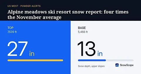
Fresh snow across the US West has built depths well above normal. At Palisades Tahoe Alpine Meadows, upper slopes hold 75 cm (measured 2026-11-18), compared to 10 cm typical for mid-November.
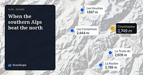
In 24 of 46 winters, resorts on the Italian and southern French side of the Alps had a relatively bigger winter than the northern side. The chart, the big years and the weather behind them.