 SnowScope
Atlas snow in January 2027: a warm month ahead, much less snow water than usual
The European seasonal forecast makes January 2027 about 2 °C warmer than usual over the Atlas, with close to normal precipitation. Combined with 45 past winters, the odds lean clearly towards less snow: about 69 million m³ of snow water in Morocco's mountains in a typical month of this kind, instead of the usual 206.
See the live snow forecast for Atlas in the SnowScope appSnow depth, powder alerts and the 3D map, free.
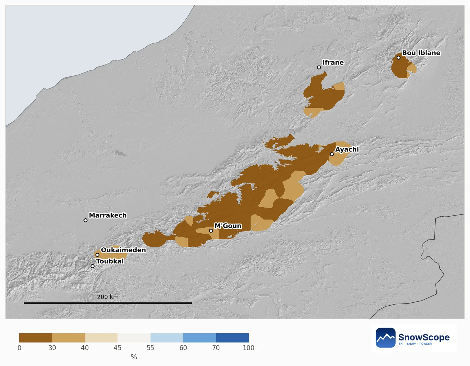
Leaner odds on every snowy part of the Atlas
Our map compares every Atlas mountain area of about 10 km with its own past Januaries and shows only areas that usually have snow in January. All of them lean leaner: the chance of a deeper snow cover than in a usual January goes from 24 % to 35 %, with a middle value of 28 %. No area leans snowier.
What the European forecast says
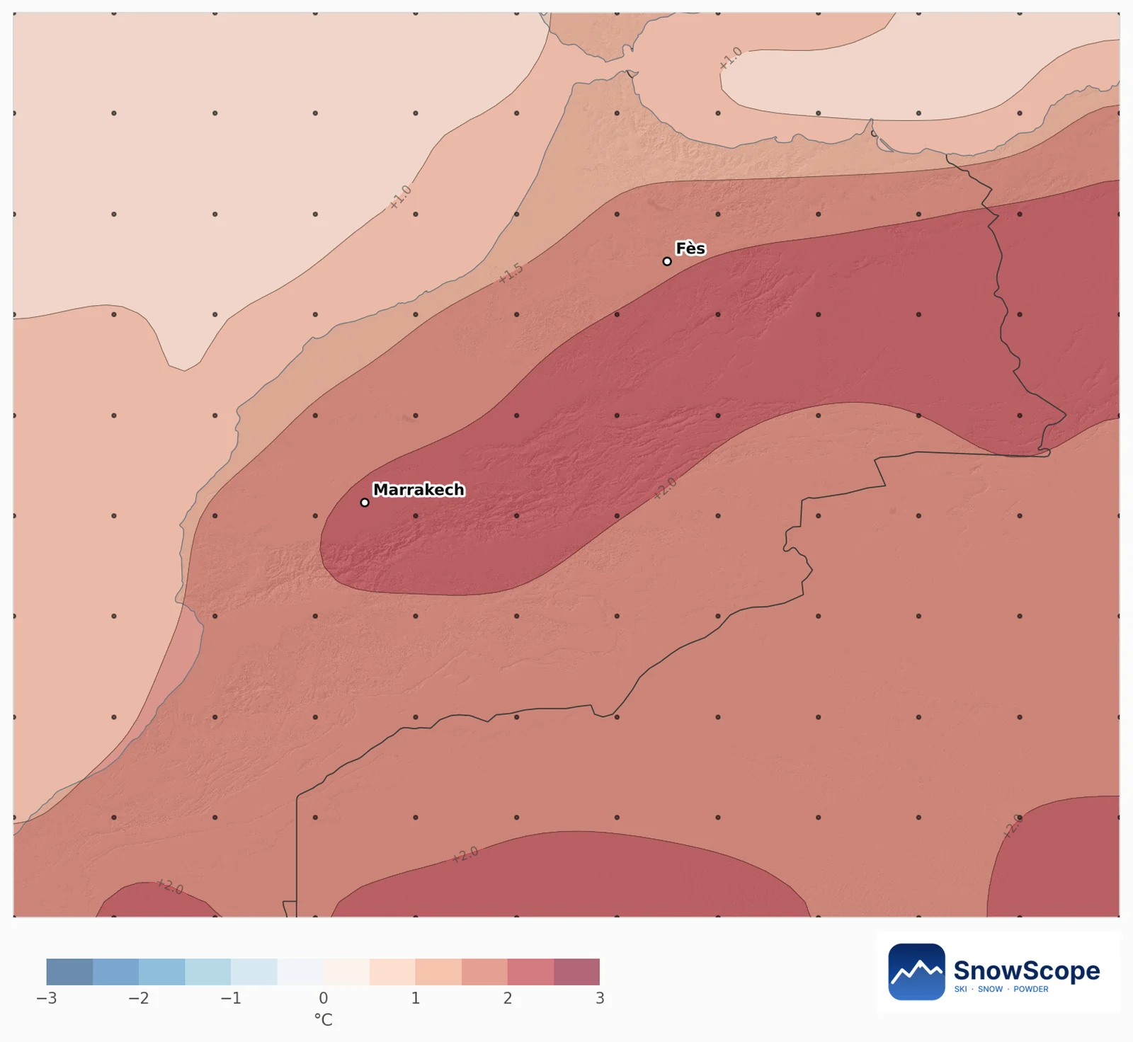
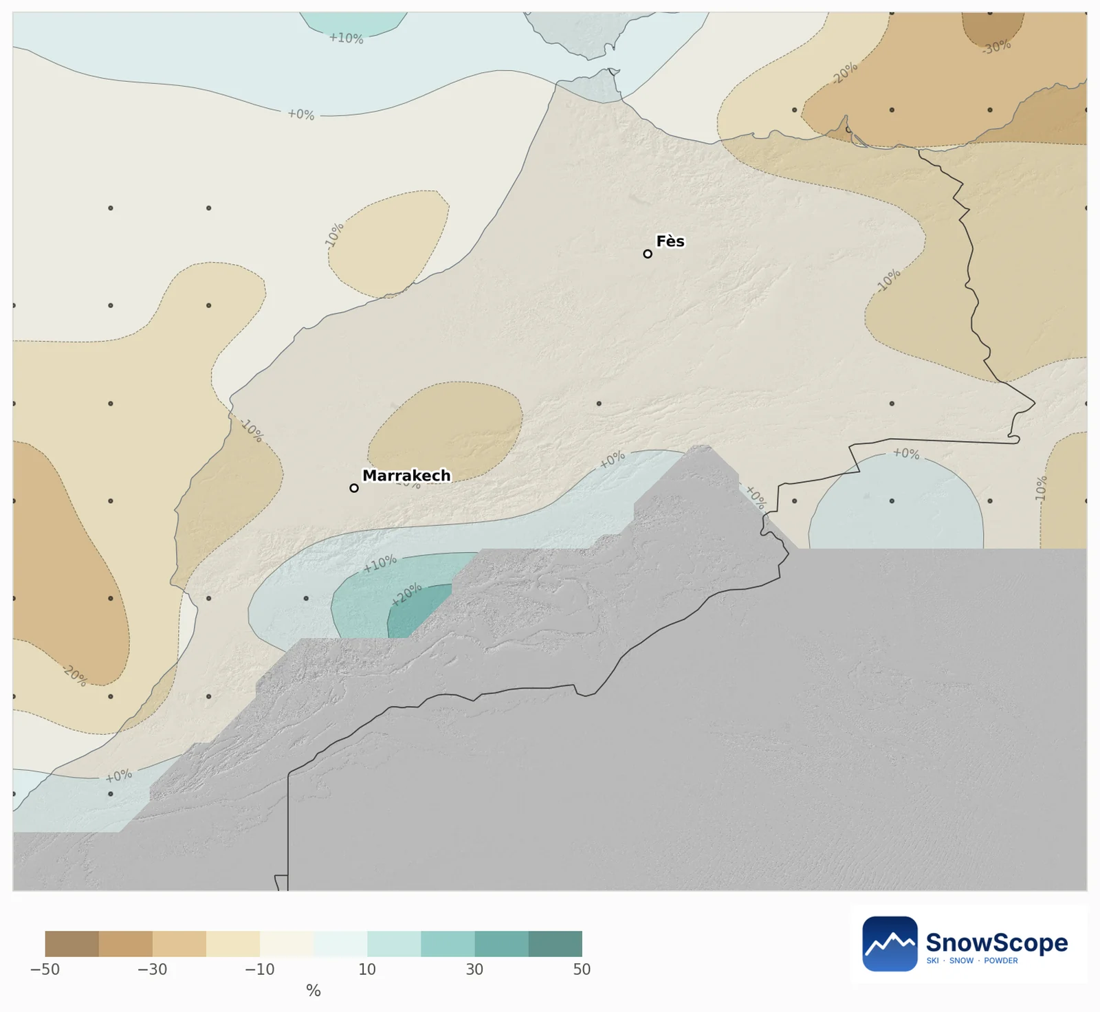
Over the mountain parts of the river basins, the 51 runs make January 1.9 to 2.2 °C warmer than usual, and 92 to 94 % of the runs agree on warmer. Precipitation stays close to usual, between 5 % below and 1 % above.
In the Atlas a few degrees matter a lot: they decide whether a storm leaves snow or rain between about 2000 and 2500 m, and how fast the snow melts afterwards under the strong sun.
Snow depth and snow water on the high massifs
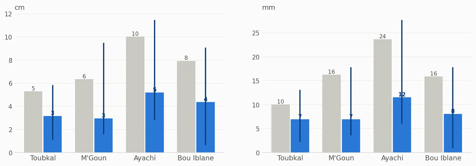
On the high ground of the four big massifs (above 2500 m, Bou Iblane above 2300 m), the month's average snow depth is usually 5 cm on the Toubkal massif, 6 cm on M'Goun, 10 cm around Ayachi and 8 cm on Bou Iblane. These are averages over all slopes, including sunny ones that melt fast, so the north faces hold much more. The outlook roughly halves them: 3, 3, 5 and 4 cm.
Snow water equivalent (SWE) is the water you would get by melting the snow: 1 mm is 1 litre per square metre. A usual January holds 10 mm on Toubkal, 16 mm on M'Goun, 24 mm on Ayachi and 16 mm on Bou Iblane; the outlook is 7, 7, 12 and 8 mm. The snow-covered share of the high ground drops from 69 % to 41 % on M'Goun and from 77 % to 60 % on Ayachi.
Water for the rivers
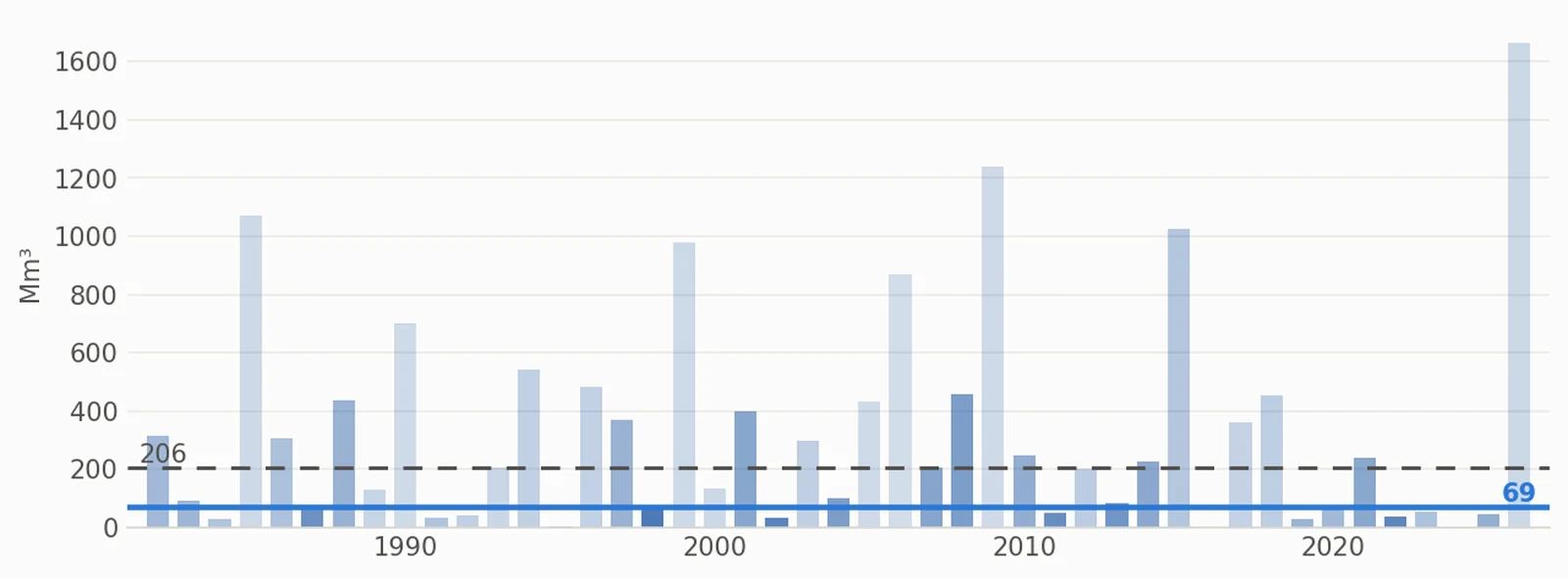
Summed over all of Morocco's mountains, a usual January stores 206 million m³ of water in the snow. The outlook is 69 million m³, most likely between 31 and 235, and the chance of more than usual is only 31 %.
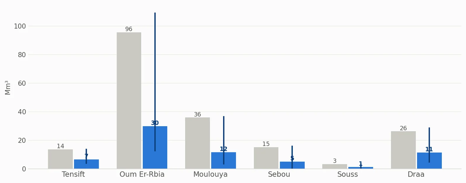
Oum Er-Rbia holds the most: usually 96 million m³, this year's outlook 30. Moulouya follows (36, outlook 12), then Draa (26, outlook 11), Sebou (15, outlook 5) and Tensift (14, outlook 7). This snow melts into the rivers and dams in spring, so a lean January matters unless February and March catch up.
How sure is this?
The past Januaries whose weather looked most like this forecast are 2016, 2024 and 1998. A monthly outlook only tilts the odds: one cold Atlantic storm can still bring a big snowfall, so follow the 7-day forecast.
Tips for skiers
- For ski or snow trips in January, plan with the 7-day forecast and go after a storm, not before.
- The highest north-facing slopes keep snow longest in a warm month.
- Follow the snow and the snow line on the SnowScope map, day by day.
References and credits
- ECMWF SEAS5 seasonal forecasts, Copernicus Climate Change Service (C3S) cds.climate.copernicus.eu/datasets/seasonal-postprocessed-single-levels
- ERA5 monthly averaged data, Copernicus Climate Change Service (C3S) cds.climate.copernicus.eu/datasets/reanalysis-era5-single-levels-monthly-means
About these numbers
Method. Temperature and precipitation: the seasonal forecast of the European weather centre (ECMWF SEAS5, 51 runs started 1 November 2026, anomalies against its own 1993-2016 reforecasts, about 100 km grid). For every winter from 1982 to 2026 we compare the weather of that month (ERA5) with each forecast run; the winters that look most alike count more, and their snow gives the odds. Snow depth and snow water equivalent (SWE, the water you get by melting the snow: 1 mm = 1 litre per square metre) come from the Snow_Hydro 1 km Morocco snow model (degree-day, evolving density, ERA5-Land downscaled), winters 1982 to 2026; snow water volume = SWE x area.
Cite this report
For research, teaching or the press: the numbers and charts are free to reuse under CC BY 4.0 with this citation.
SnowScope (2026), Atlas snow in January 2027: a warm month ahead, much less snow water than usual, https://snowscope.app/blog/en/2026/11/atlas-january-2027-snow-outlook.html, accessed 2026-11-10
SnowScope (Atlas Labs). (2026, November 10). Atlas snow in January 2027: a warm month ahead, much less snow water than usual. SnowScope snow reports. https://snowscope.app/blog/en/2026/11/atlas-january-2027-snow-outlook.html
BibTeX
@misc{snowscope2026atlasjanuary2027snowoutl,
  author       = {{SnowScope (Atlas Labs)}},
  title        = {Atlas snow in January 2027: a warm month ahead, much less snow water than usual},
  year         = {2026},
  month        = nov,
  howpublished = {\url{https://snowscope.app/blog/en/2026/11/atlas-january-2027-snow-outlook.html}},
  note         = {Published 2026-11-10 10:59 UTC; accessed 2026-11-10}
}· CC BY 4.0 · Methods, data and tools →
Follow Atlas
Free: a message when fresh snow is coming, and the forecast every morning.

More snow reports
Above 1,500 m around Toubkal, the ground was white for 94 days in winter 2025-26, the most in 26 winters of satellite images. How low the snow came, when it left, and how this winter compares with 2008-09 and the dry years.
On November 10, the freezing level reaches 5,313 ft (1,620 m) above Northeast summits, bringing rain before 20–25 cm of snow arrives.

Northeast forecast made 10 November: 10 in (25 cm) of new snow arriving through 13 November will transform snow cover from 1 resort to 62.