 SnowScope
Will Montenegro see enough snow in two weeks: 11 cm, then 22 cm?
Our model forecasts 11 cm of snow in the week ahead and 22 cm in the week of November 24 to 30. Most of this snow will fall at high elevations, above 2100 metres.
See the live snow forecast for Ski centar Savin kuk in the SnowScope appSnow depth, powder alerts and the 3D map, free.
Two weeks of buildup ahead
The outlook for the next two weeks shows a step change. This week, our model estimates a peak of 11 centimetres of new snow across the country. The more active period begins on November 20, when our model signals the start of snow events. The largest single-day fall is modelled for November 23, when about 9 centimetres is forecast. The second week—November 24 to 30—brings the larger accumulation: 22 centimetres modelled as the maximum for that period.
This is a significant swing from today. In the past 72 hours, only 4 centimetres of snow has accumulated across Montenegro (the maximum recorded). The water stored in this two-week snowfall will mainly concentrate above 2100 metres, where the snow line sits at the moment.
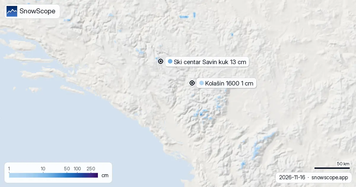
| Resort | Snow depth | New snow, 72 h | Coming, next days | Top |
|---|---|---|---|---|
| Ski centar Savin kuk | 13 cm | 15 cm | 4 cm | 2,175 m |
| Kolašin 1600 | 1 cm | 3 cm | 0 cm | 2,028 m |
Days 1–3: a pause before the event
The immediate outlook is quiet. Through November 19, our model shows no new snow is forecast across Montenegro as a whole. The next three days will stay dry. Snow coverage is at its lowest: today only 1 per cent of the country is white, down from 130 square kilometres yesterday to 80 square kilometres now. This decline is natural—warmer air is working on the existing thin snow at lower elevations.
Snow will return from November 20 onward. The dry period ahead is important for stability assessment if you plan to work at high elevations on existing snow.
The shrinking snowpack and recovery ahead
The past week has been rough for the snowpack. Seven days ago, 390 square kilometres of Montenegro were snow-covered. Today that figure is 80 square kilometres—a loss of 310 square kilometres in one week. This rapid shrinkage is typical of early November, when solar radiation and air temperatures can still melt what fell in autumn storms. The water equivalent of that lost snow has run to lower elevations and streams.
The recovery comes next week. Beginning November 20, the model signals a shift from melt to accumulation. The 22-centimetre peak in week two suggests a substantial recharge of the mountain water stores after this current dry spell.
Where the highest mountains are capturing snow
The Prokletije mountains in the north have been the focus of recent precipitation, with 29 centimetres recorded in the past 72 hours. Durmitor has accumulated 17 centimetres in the same period, while Bjelasica has received 5 centimetres. These figures show the highest ranges are already responding to atmospheric moisture.
Ski centar Savin kuk, the country's highest resort at 2175 metres, has 13 centimetres on the ground today and has received 15 centimetres in the past 72 hours. This is the best measured snow depth currently in Montenegro. Kolašin 1600, at 2028 metres, sits at only 1 centimetre depth, showing how thin the snow is near the current snow line.
Elevation bands and the snow line
Snow is concentrated in a narrow vertical layer. Between 1500 and 2000 metres elevation, only 1 per cent of the terrain is snow-covered. The important layer is between 2000 and 2500 metres, where 49 per cent of the area is snow-covered and the mean depth is 2 centimetres. The snow line at 2100 metres separates the melting zone below from the accumulation zone above.
For the next two weeks, as the model shows up to 22 centimetres of new snow, that accumulation will develop mainly above 2000 metres. Early-season snow at high elevation can remain thin and patchy. By November 30, we expect depth to increase, but rocks and bare ground may still be visible through the cover on steeper south-facing slopes.
Tips for skiers
- Above 2100 metres is where snow will collect over the next two weeks; lower elevations will continue to see marginal conditions.
- The snowiest day in the forecast is November 23, when 9 centimetres of new snow is modelled; plan high-elevation trips for the period from November 23 onward.
- Ski centar Savin kuk is the best current option with 13 centimetres depth and 2175 metres elevation; it will capture most of the upcoming snow.
- If you venture off-piste, check the latest official avalanche bulletin; early-season snow can be unstable when new accumulation sits on thin existing cover.
- Snow will be thin for the first weeks of the season; rocks and bare ground may be close to the surface, especially below 2000 metres.
About these numbers
Resort snow depths are the deepest snow on the resort's upper slopes from the SnowScope snow model (about 1 km, run of 16 November); they are estimates for an area, not a measurement at one point. Station values are measurements on the date shown. Forecasts can change. Always read the official avalanche bulletin before going off-piste.
Cite this report
For research, teaching or the press: the numbers and charts are free to reuse under CC BY 4.0 with this citation.
SnowScope (2026), Will Montenegro see enough snow in two weeks: 11 cm, then 22 cm?, https://snowscope.app/blog/en/2026/11/montenegro-snow-report-16-november-2026.html, accessed 2026-11-16
SnowScope (Atlas Labs). (2026, November 16). Will Montenegro see enough snow in two weeks: 11 cm, then 22 cm?. SnowScope snow reports. https://snowscope.app/blog/en/2026/11/montenegro-snow-report-16-november-2026.html
BibTeX
@misc{snowscope2026montenegrosnowreport16no,
  author       = {{SnowScope (Atlas Labs)}},
  title        = {Will Montenegro see enough snow in two weeks: 11 cm, then 22 cm?},
  year         = {2026},
  month        = nov,
  howpublished = {\url{https://snowscope.app/blog/en/2026/11/montenegro-snow-report-16-november-2026.html}},
  note         = {Published 2026-11-16 20:42 UTC; accessed 2026-11-16}
}· CC BY 4.0 · Methods, data and tools →
Ski centar Savin kuk: snow and temperature by height, this winter vs last (tools) →
Follow Ski centar Savin kuk
Free: a message when fresh snow is coming, and the forecast every morning.

More snow reports

Planning a December trip to Baqueira Beret? See our snow history, ticket prices starting at 70,00 € for a 1-day pass, and how it compares to Astún-Candanchú.

Aspen Snowmass compared: Snowmass has about 75 in (190 cm) at the usual peak at mid-mountain over 46 past winters, Aspen Mountain about 69 in (174 cm). Terrain, access, safety.

Above 1,500 m around Toubkal, the ground was white for 94 days in winter 2025-26, the most in 26 winters of satellite images. How low the snow came, when it left, and how this winter compares with 2008-09 and the dry years.