 SnowScope
Östersund snow depth: 19 to 33 cm around Storsjön, and it is staying (13 November 2026)
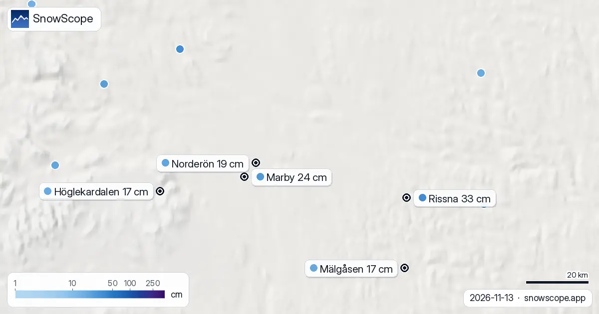
Jämtland got its winter this week. Around Storsjön, the weather stations measured between 17 and 33 cm of snow on Friday morning, most of it fallen since Wednesday. Östersund itself has no snow-depth station in town, but Norderön, 14 km away on the lake, has 19 cm and Marby, on the southern shore, 24 cm.
See the live snow forecast for Östersund in the SnowScope appSnow depth, powder alerts and the 3D map, free.The stations around the lake
Norderön went from 8 cm on Thursday to 19 cm today. Marby: 9 cm to 24 cm. Rissna, 38 km to the east: 10 cm to 33 cm. Höglekardalen, at 595 m in the hills to the south-west, and Mälgåsen both measured 17 cm. Kaxås-Åflo, to the north-west, already had 29 cm yesterday and now has 31 cm.
On Monday most of these stations had bare ground. Two days of steady snow did all of this.
How it compares with a normal November
Our snow history for the Östersund area, at the height of the town, covers 46 past winters. Snow on the ground on 13 November is common, 38 winters out of 46, but the middle value is only 6 cm and one winter in four had 15 cm or more.
So today's 19 to 24 cm is roughly what the town usually has around the start of December, when the normal is about 17 cm; by mid-December it is about 29 cm. In 2023-24 this date had 56 cm, the deepest in our record. Last winter had just 2 cm.
A weekend that keeps it
No thaw is coming. Saturday and Sunday are dry, from about -4 °C at night to just above zero in the afternoon. On Monday both forecasts we read bring a little more snow, roughly 3 to 4 cm, with temperatures around zero. The cover should stay, and settle a little.
Tips for skiers
- This is a real first-snow weekend: forest walks, sledding and the first kick-sled trips on the paths are on.
- Lake ice on Storsjön is nowhere near safe in mid-November: stay on the shore, whatever the snow looks like.
- Snow on unfrozen ground: forest roads and tracks can be soft and deep, so drive and park carefully off the main roads.
More maps (external sites)
References and credits
- SMHI, open meteorological observations (snow depth, daily) www.smhi.se/data/meteorologi/ladda-ner-meteorologiska-observationer
- Open-Meteo, weather forecast data (ECMWF and ICON models) open-meteo.com/
About these numbers
Snow depth today: measured at weather stations on the morning of 13 November 2026 (SMHI); a station reports the snow on its own small plot, so a few kilometres away and a hundred metres higher the ground can look different. Usual depth for the date: SnowScope snow history, 46 past winters (1980-81 to 2025-26), a model of the past at the city's height, not a station record. Weekend: two weather models (ECMWF IFS and DWD ICON, read through Open-Meteo), given as a range. Places and rules: the official pages listed below.
Cite this report
For research, teaching or the press: the numbers and charts are free to reuse under CC BY 4.0 with this citation.
SnowScope (2026), Östersund snow depth: 19 to 33 cm around Storsjön, and it is staying (13 November 2026), https://snowscope.app/blog/en/2026/11/ostersund-snow-depth-13-november-2026.html, accessed 2026-11-13
SnowScope (Atlas Labs). (2026, November 13). Östersund snow depth: 19 to 33 cm around Storsjön, and it is staying (13 November 2026). SnowScope snow reports. https://snowscope.app/blog/en/2026/11/ostersund-snow-depth-13-november-2026.html
BibTeX
@misc{snowscope2026ostersundsnowdepth13nove,
  author       = {{SnowScope (Atlas Labs)}},
  title        = {Östersund snow depth: 19 to 33 cm around Storsjön, and it is staying (13 November 2026)},
  year         = {2026},
  month        = nov,
  howpublished = {\url{https://snowscope.app/blog/en/2026/11/ostersund-snow-depth-13-november-2026.html}},
  note         = {Published 2026-11-13 20:49 UTC; accessed 2026-11-13}
}· CC BY 4.0 · Methods, data and tools →
Follow Östersund
Free: a message when fresh snow is coming, and the forecast every morning.

More snow reports
Ski Revelstoke's whole vertical in your head first: the snow at the summit, mid-mountain and the valley base in 46 past winters, and when each part is at its best.

How to spend a first day at Park City Mountain, Utah, and when to go: our snow history gives about 71 in (180 cm) at the usual mid-mountain peak over 46 past winters.