 SnowScope
Pyrenees snow from space: 26 winters of snow cover, and what the stations say about the dry years
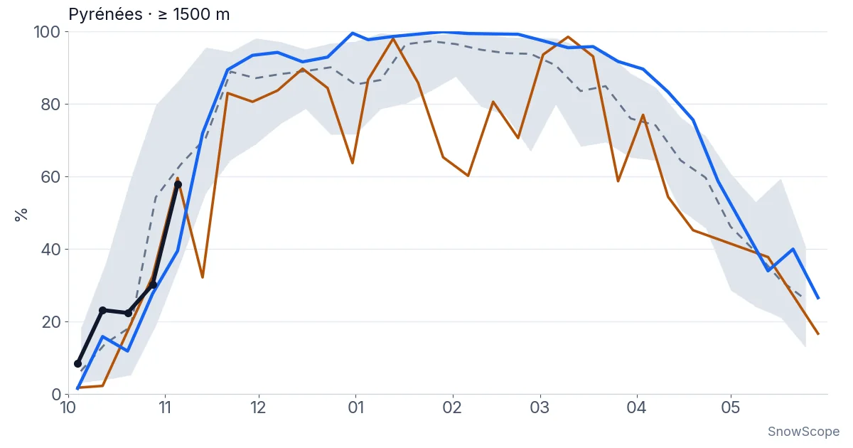
Start with the first chart. The grey band is a normal Pyrenean winter as seen from space, the brown line is 2023-24, the blue line is 2025-26 and the black dots are this autumn. Last winter the ground above 1,500 m stayed white for about 164 days between November and April, the third-longest of 26 winters. It came straight after three thin winters in a row, a run the station records had not seen since 1990-91.
See the live snow forecast for Piau-Engaly in the SnowScope appSnow depth, powder alerts and the 3D map, free.
What the satellite counts
The satellite looks at the whole range in squares of 500 m and keeps, for every 8 days, the answer to one simple question: was this square white at least once? We kept the squares above 1,500 m between the Basque hills and the Mediterranean, an area of 9,913 km², and counted how many days each square was white from 1 November to 30 April. The best possible score is 184 days.
Clouds are the enemy. When a square is hidden for all 8 days, we keep its last clear answer. For the chart we drop any 8-day view in which less than 80 % of the area was clear. That is why some lines are jumpy: a cloudy week is a missing point, not a melt.
Twenty-six winters in one number each
In the 20 winters from 2000-01 to 2019-20, the middle value is 151 white days. One winter in five fell below 142 days, and that is our line for a low-snow winter. The longest seasons were 2008-09 (170 days), 2017-18 (165) and 2025-26 (164). The shortest were 2006-07 and 2020-21 (128 each) and 2022-23 (131).
Now the part that matters. Before 2019-20, 3 of 19 winters fell below the line: 2006-07, 2011-12 and 2015-16. Since then, 4 of 7 have: 2019-20, 2020-21, 2022-23 and 2023-24. 2024-25 landed at 142, exactly on the line. Seven winters are too few to call that a trend, but it is not a comfortable start to a decade.
Last winter broke the run. It was long in the west and in the east alike: 164 white days west of the Ossau valley and 162 in the eastern part of the range, third and second in their own series.
What the satellite cannot see
A satellite sees white, not deep. A thin layer of snow after a cold front counts as much as 2 m of snowpack in a north-facing bowl. It also tends to see a little more snow than there is, because one white day in 8 is enough. So our white days are good for comparing winters with each other, and less good as an exact number of skiing days.
For depth, we need people and instruments on the ground.
Ten stations with long memories
We picked 10 stations on the French side with long, well-filled records, from La Pierre-Saint-Martin in the west to the Canigou in the east, between 1,460 m and 2,445 m. Six are in ski areas, where the snow is measured every day of the season. Four are automatic stations at high mountain sites. For each winter we took the mean snow depth from 1 January to 31 March, and compared it with the station's own winters from 1990-91 to 2019-20, the usual climate reference period. Below the 20th percentile means a low-snow winter: thinner than four winters in five of the reference period.
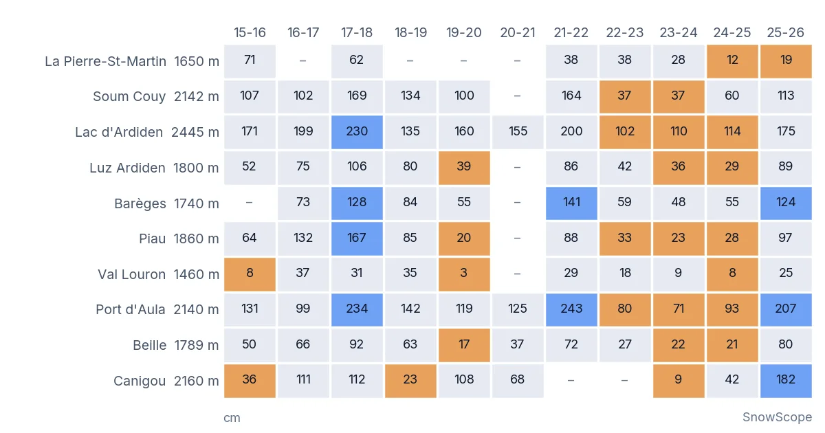
The second chart shows the last eleven winters. Orange cells are low-snow winters, blue cells are big ones, above the 80th percentile. The numbers are the mean depth in cm.
Was there a snow drought? Yes, for three winters
The stations do not hedge. In 2022-23, 5 of 9 stations were below their 20th percentile. In 2023-24 it was 7 of 10, and in 2024-25 again 7 of 10. Since 1990-91, that is the only run of three winters in a row with at least half of the stations in low-snow territory. The two earlier runs, 1991-92 to 1992-93 and 2006-07 to 2007-08, lasted two winters each.
Some examples. At Piau, at 1,860 m, the usual mean depth is 62 cm; in 2023-24 it was 23 cm. At the automatic station of Lac d'Ardiden, at 2,445 m, three winters in a row stayed just above a metre (102, 110 and 114 cm), against a usual 170 cm. In 2024-25 the satellite counted 142 white days, right on the line, while the stations measured thin snow. White, but thin: exactly the gap between the two methods.
Then came 2025-26. Only 1 station of 10 was below its line. The Canigou automatic station measured a mean of 182 cm, the highest of its 27 winters, and Port d'Aula 207 cm, its sixth-highest in 29. The exception was the far west: at La Pierre-Saint-Martin, at 1,650 m, the mean was 19 cm against a usual 46 cm, a low-snow winter for the second year in a row, even though the satellite saw the western slopes white for a long season.
And this autumn?
Too early to say much, and we will not pretend otherwise. In the 8 days from 1 November, 58 % of the ground above 1,500 m was seen white at least once, the same as the middle value of past autumns at that date. The high automatic stations had a few centimetres, like most years in early November. The black dots in the first chart will become a line over the coming weeks.
How sure are we?
Sure that 2022-23 to 2024-25 was a low-snow run at the stations: the rule is simple and the stations agree. Fairly sure that 2025-26 was a long, white winter across the range: both methods say so. Less sure about the trend: 26 winters of satellite data is short, and the stations are all on the French side, so the Spanish and Andorran slopes are not in this station count. And a reminder: these are measurements at a few points and a satellite view at 500 m, not the snow on any given piste.
Tips for skiers
- In the Pyrenees, a good winter at 2,000 m can still be a poor one at 1,500 m: pick the higher resorts when the start is thin.
- The far west and the east often have different winters; check each resort's own snow history before booking.
- A white satellite view means snow cover, not deep snow: check measured depths before planning a ski tour.
- Always read the official avalanche bulletin before going off-piste.
References and credits
- Gascoin, S. et al. (2015). A snow cover climatology for the Pyrenees from MODIS snow products. Hydrology and Earth System Sciences 19, 2337-2351. doi.org/10.5194/hess-19-2337-2015
- Hall, D. K. and Riggs, G. A. MODIS/Terra Snow Cover 8-Day L3 Global 500m SIN Grid, Version 61. NASA National Snow and Ice Data Center DAAC. nsidc.org/data/mod10a2/versions/61
- Météo-France: daily climatological data, open data (Licence Ouverte Etalab 2.0). meteo.data.gouv.fr
- SnowScope: Global warming and the decline of snow in the Pyrenees: what 46 winters show. snowscope.app/blog/en/2026/11/pyrenees-snow-decline-global-warming-46-winters.html
About these numbers
Satellite: MODIS Terra 8-day maximum snow extent (MOD10A2, collection 6.1, 500 m, NASA NSIDC DAAC), 1 October 2000 to 8 November 2026. Domain: lat 42.0-43.4 N, lon 2.0 W-3.3 E, ground at or above 1,500 m (Copernicus GLO-90 DEM), 9,913 km². White days = 8-day periods with snow from 1 November to 30 April x 8 (a cloudy period keeps the previous clear state); chart: periods with at least 80 % clear view. Reference 2000-01 to 2019-20; low-snow winter = below its 20th percentile. Stations: Météo-France daily climatological data (snow depth at 06 UTC, else the day's maximum), 10 stations: La Pierre-Saint-Martin, Soum Couy, Luz Ardiden, Lac d'Ardiden, Barèges, Piau, Val Louron, Port d'Aula, Beille, Canigou; winter value = mean depth 1 January-31 March with at least 60 days of data; reference 1990-91 to 2019-20 (the automatic stations from 1996-97); low = below the 20th percentile. Spanish and Andorran stations: no open daily series available to us. All numbers: SnowScope analysis scripts, 10 November 2026.
Cite this report
For research, teaching or the press: the numbers and charts are free to reuse under CC BY 4.0 with this citation.
SnowScope (2026), Pyrenees snow from space: 26 winters of snow cover, and what the stations say about the dry years, https://snowscope.app/blog/en/2026/11/pyrenees-snow-cover-satellite-stations-low-snow-winters.html, accessed 2026-11-10
SnowScope (Atlas Labs). (2026, November 10). Pyrenees snow from space: 26 winters of snow cover, and what the stations say about the dry years. SnowScope snow reports. https://snowscope.app/blog/en/2026/11/pyrenees-snow-cover-satellite-stations-low-snow-winters.html
BibTeX
@misc{snowscope2026pyreneessnowcoversatelli,
  author       = {{SnowScope (Atlas Labs)}},
  title        = {Pyrenees snow from space: 26 winters of snow cover, and what the stations say about the dry years},
  year         = {2026},
  month        = nov,
  howpublished = {\url{https://snowscope.app/blog/en/2026/11/pyrenees-snow-cover-satellite-stations-low-snow-winters.html}},
  note         = {Published 2026-11-10 18:19 UTC; accessed 2026-11-10}
}· CC BY 4.0 · Methods, data and tools →
Piau-Engaly: snow and temperature by height, this winter vs last (tools) →
Follow Piau-Engaly
Free: a message when fresh snow is coming, and the forecast every morning.

More snow reports
Baqueira-Beret sits in the Val d'Aran, on the Atlantic side of the Pyrenees. What that means for its snow, tested with 46 past winters against La Molina, and when to go.
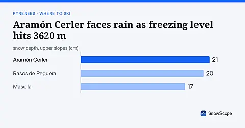
Freezing level reaches 3620 m on Sunday 8 November, above Aramón Cerler's 2618 m top, bringing rain-on-snow risk (forecast from 6 November data).
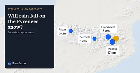
Freezing level reaches 3400m–3600m over the next three days, bringing rain to the snowpack from 09–11 November. Forecast from 08 November.