 SnowScope
Val Thorens powder forecast next week (23–29 November 2026): 30 cm up top
Next week's snow numbers for Val Thorens: 30 cm at the top, 28 cm at mid-mountain, 25 cm at the base, all as the middle of a range for 23–29 November. The top's range runs from 13 to 46 cm, which says as much as the middle value does.
See the live snow forecast for Val Thorens in the SnowScope appSnow depth, powder alerts and the 3D map, free.
Best day, best slopes
If you can pick one day, take the one that follows Wednesday 25 November, when 10 cm (up to 11 cm) has landed on the upper mountain.
Go high: depth is safest on the Péclet glacier and Cime Caron, and the best skiing should be on the Péclet side and the Cime Caron bowl, where shade keeps the snow dry. Treat the Orelle side, which faces the sun and the Maurienne valley as the weak point.
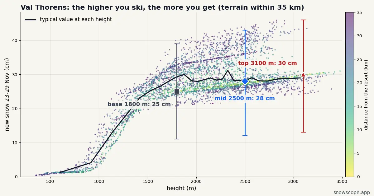
How the week of 23–29 November adds up in Val Thorens
At the top (around 3100 m) the week totals 30 cm, 13–46 cm across our range. Mid-mountain around 2500 m gets 28 cm (12–43 cm), and the base around 1800 m 25 cm (11–39 cm).
The snow is not spread evenly. The days that matter at the top are Wednesday 25 (10 cm, up to 11), Thursday 26 (8 cm, up to 13) and Sunday 29 (6 cm, up to 12); the rest of the week is close to dry.
This week in Val Thorens: the set-up
Before next week even starts, Val Thorens should be holding a deep fresh layer up high: 82 cm from Tuesday 17 to Friday 20 November (59–105 cm), while the base sees 42 cm. The second storm then builds on it.
Snow or rain at the bottom?
The base gets nearly as much as the top (25 against 30 cm), which means the snow line stays below the lowest lifts for most of the week. Snow down to the village is the likely picture.
Val Thorens is the highest resort village of the Three Valleys, and it usually opens early because of that.
Next door, the same week
For comparison, the upper slopes of the closest big resorts collect Méribel (10 km away) 28 cm, Courchevel (14 km away) 27 cm and La Plagne (27 km away) 28 cm; Val Thorens sits at 30 cm.
Nothing to separate them on snow alone; the choice comes down to the terrain you want.
What could change
Reasonably, with a caveat. The snow is coming to Val Thorens, but the top could end up anywhere between 13 and 46 cm, and the middle value of 30 cm is only the halfway mark.
The days closest to now are the most reliable; the end of the week is the least.
Tips for skiers
- Fresh snow on a young snowpack: read the French avalanche bulletin (BERA) for the massif before any off-piste plan.
- Opening dates are the resort's call; our numbers only say how much snow is coming.
- Watch the forecast midweek: the top's range is 13–46 cm.
More maps (external sites)
About these numbers
Snow numbers: our two-week snow forecast issued on 16 November 2026, read at three heights of the resort (top, mid-mountain, base). Each total is the middle of a range, with a low and a high case. These are estimates for the slopes, not resort measurements, and forecasts move from day to day: check the live map before you go.
Cite this report
For research, teaching or the press: the numbers and charts are free to reuse under CC BY 4.0 with this citation.
SnowScope (2026), Val Thorens powder forecast next week (23–29 November 2026): 30 cm up top, https://snowscope.app/blog/en/2026/11/val-thorens-powder-forecast-next-week-23-29-november-2026.html, accessed 2026-11-16
SnowScope (Atlas Labs). (2026, November 16). Val Thorens powder forecast next week (23–29 November 2026): 30 cm up top. SnowScope snow reports. https://snowscope.app/blog/en/2026/11/val-thorens-powder-forecast-next-week-23-29-november-2026.html
BibTeX
@misc{snowscope2026valthorenspowderforecast,
  author       = {{SnowScope (Atlas Labs)}},
  title        = {Val Thorens powder forecast next week (23–29 November 2026): 30 cm up top},
  year         = {2026},
  month        = nov,
  howpublished = {\url{https://snowscope.app/blog/en/2026/11/val-thorens-powder-forecast-next-week-23-29-november-2026.html}},
  note         = {Published 2026-11-16 11:18 UTC; accessed 2026-11-16}
}· CC BY 4.0 · Methods, data and tools →
Val Thorens: snow and temperature by height, this winter vs last (tools) →
Follow Val Thorens
Free: a message when fresh snow is coming, and the forecast every morning.

More snow reports
Les Menuires snow report for 13 November 2026: 28 cm at the top (2838 m), none lying at 2112 m or 1386 m. About 80 cm due at the top in seven days, snow line around 1500 to 1700 m. Why Val Thorens, 450 m higher up the same valley, already has more.

Alpine day passes from 36 EUR: nine resorts compared by price, kilometres of runs and the snow they usually hold, to find the best day of skiing for your money.
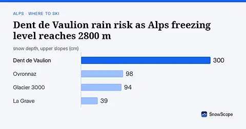
Dent de Vaulion's upper slopes face rain as freezing level reaches 2800 m Thursday; higher resorts get fresh snow for the weekend.