 SnowScope
Whistler peaks at 85 cm as powder arrives; best weeks are 12-14
Fresh snow is spreading across Western Canada, with Whistler Blackcomb reaching 85 cm on upper slopes and 100+ cm forecast for the next three days. However, the region's peak accumulation weeks are 12-14 (late March to early April), meaning peak season is still four months away.
See the live snow forecast for Ski Callaghan in the SnowScope appSnow depth, powder alerts and the 3D map, free.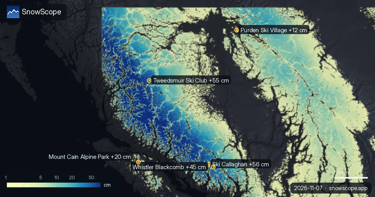
Fresh snow from yesterday's storm
A storm system delivered measurable snow to most major resorts over the 72 hours through Saturday, November 7th. Ski Callaghan received the heaviest resort deposit, accumulating 56 cm at upper slopes—a nearby burst of heavier snow dropped 98 cm just 26 kilometres away. Whistler Blackcomb saw 45 cm in the same period; Tweedsmuir Ski Club accumulated 55 cm and Mount Cain Alpine Park 20 cm.
The region-wide snow-covered area declined from 310,410 km² on November 5th to 300,720 km² by November 7th, suggesting that lower elevations and marginal terrain shed cover as freezing levels rose to between 1,500 and 2,380 metres at Whistler during Saturday.
| Resort | Snow depth | New snow, 72 h | Coming, next days | Top |
|---|---|---|---|---|
| Ski Callaghan | 48 cm | 56 cm | 99 cm | 998 m |
| Tweedsmuir Ski Club | 55 cm | 55 cm | 26 cm | 1,650 m |
| Whistler Blackcomb | 85 cm | 45 cm | 103 cm | 2,259 m |
| Mount Cain Alpine Park | 66 cm | 20 cm | 74 cm | 1,616 m |
| Purden Ski Village | 20 cm | 12 cm | 4 cm | 1,365 m |
Forecast: 100+ cm in three days
The outlook signals a dramatic shift. Our snow model forecasts 99 to 103 centimetres across the top resorts over the next three days (November 8th to 10th). Whistler Blackcomb is expected to gain 103 cm; Ski Callaghan, 99 cm; Mount Cain Alpine Park, 74 cm.
This payload comes with a temperature reset: freezing levels collapse on November 9th (down to 70–210 metres at the highest elevations), meaning even lower terrain may see wet snow briefly before stabilising. For powder-focused skiers, Sunday into Monday will offer the richest days; Tuesday's 3 cm at Whistler and 34 cm at Ski Callaghan mark the system's tail end.
Depths ranked: Whistler leads
By depth, Whistler Blackcomb dominates the region at 85 cm on upper slopes today, though this conceals an awkward reality: the mid-mountain at 1,456 metres holds only 37 cm—just half of what this date usually receives. Mount Cain Alpine Park sits second with 66 cm. Tweedsmuir Ski Club, at the highest elevation (1,650 m) and best-protected from early-season warmth, holds a more seasonal 55 cm.
Ski Callaghan's modest 48 cm reflects its lower average elevation (998 m summit), while Purden Ski Village lags far behind at 20 cm, with marginal conditions ahead: our model shows only 2 cm new snow in the next week.
Way behind the 46-winter average
Set Ski Callaghan's 13 cm mid-mountain measurement against 46 previous November 7ths, and the picture sharpens. This depth ranks deeper than only 10 of those winters—meaning 36 past Novembers started thicker. The long-term average at this date and height is 38 cm; today's 13 cm represents 34 per cent of normal.
Whistler's mid-mountain tells a similar story: 31 cm measured, against a typical 72 cm. Early snow is inherently thin and unreliable. If you venture off-piste, check the latest official avalanche bulletin for your area and probe carefully for rocks and gaps.
Peak season peaks in spring
The real finding here sits in the calendar. Ski Callaghan's historical record shows the richest accumulation weeks falling in weeks 12, 13, and 14 of the year—late March through early April. We are currently in week 45 (early November). The best seasons, in other words, are still four to five months distant.
This arriving powder is valuable for establishing base and opening terrain. But the region's most reliable, deepest snow comes later in spring. Our snow model is confident in the near-term forecast; the week-to-week pattern beyond November remains inherently uncertain.
Tips for skiers
- Sunday and Monday deliver the most snow; forecast 60+ cm at Whistler and Ski Callaghan between them.
- Watch freezing levels Monday morning—they plunge to near-ground level (70–210 m), triggering brief wet snow that stabilises quickly.
- Whistler's upper elevations (above 1,900 m) hold powder best; mid-mountain and lower runs warm and consolidate faster.
- Skip Purden Ski Village this week (4 cm total forecast); prioritise Whistler, Ski Callaghan, or Mount Cain.
- Off-piste skiers: check official avalanche bulletins and probe thoroughly—thin early-season snow conceals rocks.
About these numbers
Resort snow depths are the deepest snow on the resort's upper slopes from the SnowScope snow model (about 1 km, run of 6 November); they are estimates for an area, not a measurement at one point. Station values are measurements on the date shown. Forecasts can change. Always read the official avalanche bulletin before going off-piste.
Official avalanche bulletins: Avalanche Canada
Cite this report
For research, teaching or the press: the numbers and charts are free to reuse under CC BY 4.0 with this citation.
SnowScope (2026), Whistler peaks at 85 cm as powder arrives; best weeks are 12-14, https://snowscope.app/blog/en/2026/11/western-canada-fresh-snow-powder-alert-7-november-2026.html, accessed 2026-11-07
SnowScope (Atlas Labs). (2026, November 7). Whistler peaks at 85 cm as powder arrives; best weeks are 12-14. SnowScope snow reports. https://snowscope.app/blog/en/2026/11/western-canada-fresh-snow-powder-alert-7-november-2026.html
BibTeX
@misc{snowscope2026westerncanadafreshsnowpo,
  author       = {{SnowScope (Atlas Labs)}},
  title        = {Whistler peaks at 85 cm as powder arrives; best weeks are 12-14},
  year         = {2026},
  month        = nov,
  howpublished = {\url{https://snowscope.app/blog/en/2026/11/western-canada-fresh-snow-powder-alert-7-november-2026.html}},
  note         = {Published 2026-11-07 15:18 UTC; accessed 2026-11-07}
}· CC BY 4.0 · Methods, data and tools →
Ski Callaghan: snow and temperature by height, this winter vs last (tools) →
Follow Ski Callaghan
Free: a message when fresh snow is coming, and the forecast every morning.

More snow reports

Western Canada mountains carry 42% of their normal snow for mid-November as of 12 November, but 142 cm is forecast over the next two weeks.
Whistler Blackcomb got 75 cm of new snow at the top in a week, then a warm storm with 124 mm of water. A simple guide to base, fresh snow, rain and crust.

Whistler Blackcomb forecast to gain 47 centimetres by Saturday as snow arrives Thursday through the region, according to our model run on 4 November.