 SnowScope
Fresh snow or deep snow? Why 75 cm of new snow can still ski badly – the Whistler case
Two numbers decide a ski day, and people often mix them up. Fresh snow is what fell in the last day or days. Snow depth is everything lying on the ground. This week at Whistler Blackcomb shows why you need both, and why the water in a storm matters more than its headline.
See the live snow forecast for Whistler Blackcomb in the SnowScope appSnow depth, powder alerts and the 3D map, free.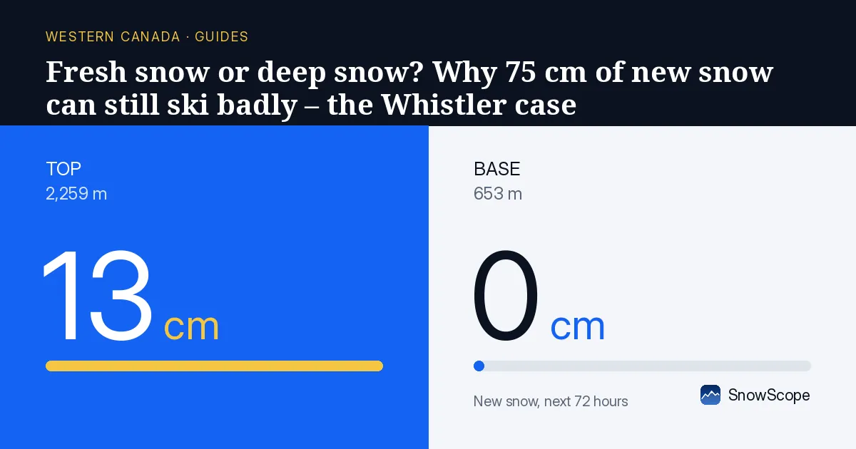
Two numbers, two different questions
Snow depth answers the question "what am I skiing on?". It is the base: the whole pile of snow between your skis and the rocks, roots and grass. Fresh snow answers a different question: "how soft and new is the top layer?". A day with a lot of fresh snow on almost no base is a day of rocks hidden just under the surface.
A snow hydrologist looks at the same pile in a third way: as water stored on the mountain. Every centimetre of snow holds some water, and every storm adds water, as snow or as rain. Where that water goes next, into the snow or out of it, decides how the surface will feel in two days.
Whistler today: the depth is almost all new
On our map for 10 November, Whistler Blackcomb has 90 cm of snow at the top (2,259 m), 47 cm at mid-mountain (1,456 m) and none at the base (653 m). In the last seven days, 75 cm of new snow fell at the top and 52 cm at mid-mountain.
Put those numbers side by side. At the top, 75 of the 90 cm arrived during the last week. At mid-mountain, the new snow of the week is even larger than the depth left on the ground, because the fresh snow has already settled and some of it melted. In other words, the base is young. There is no thick, old, firm layer under it yet, which is normal for early November.
A young base is soft and full of air. It skis well when it stays cold, but it reacts strongly to warm air and rain.
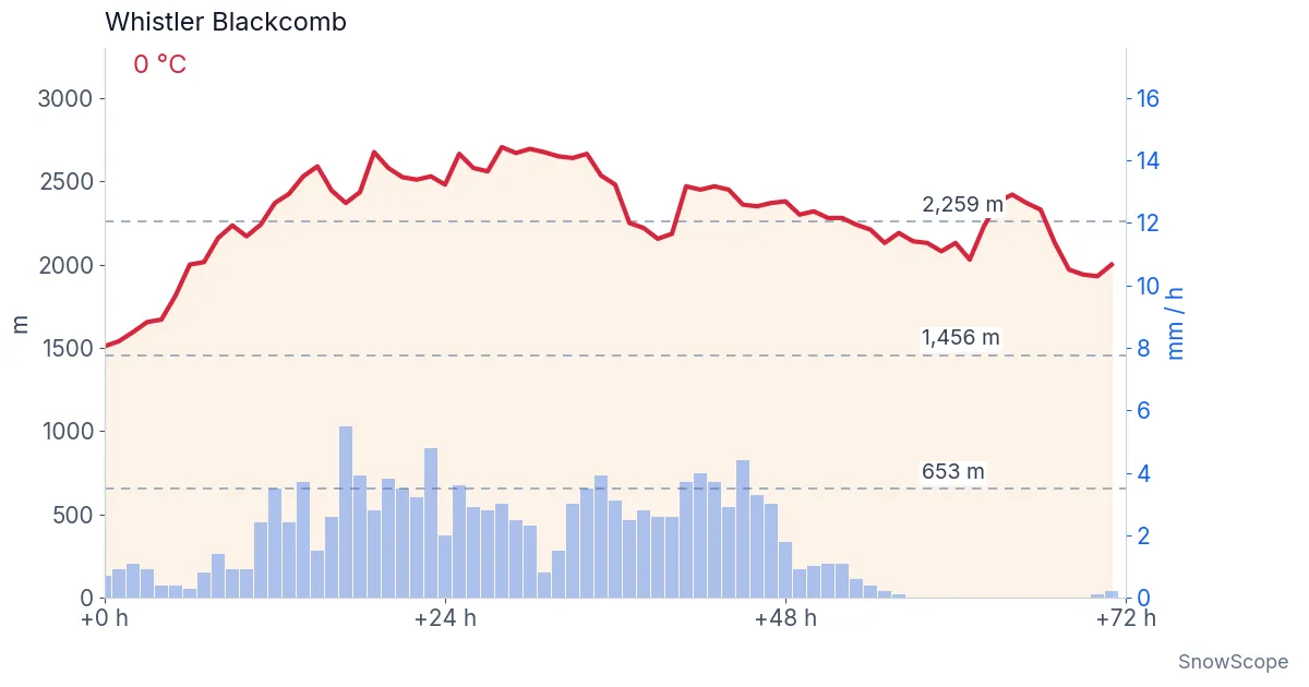
What the next 72 hours bring
The forecast made on 10 November at 14:40 UTC brings a warm, wet storm. At a point near the top of the mountain, at 2,109 m, the models in the app expect 130 mm of water over 72 hours, but only about 5 cm of it as snow. At the resort's top height, 2,259 m, they give 124 mm of water and about 13 cm of snow.
The reason is the 0 °C level, the height in the air where the temperature crosses zero. It climbs to about 2,705 m on Wednesday 11 November, higher than the top lift. On that day the air at the top stays between -2.0 °C and 0.2 °C, and at the base between 7.2 °C and 10.1 °C. Near zero at the top, with warmer air above, the storm brings rain, wet snow and perhaps freezing rain instead of light snow.
This is the honest part: the line between rain and snow sits very close to the top this week. Small changes in the forecast can move the snow amounts at the top up or down quite a lot. The water total is the steadier number. Watch the snow line in the app before you decide.
What 124 mm of rain does to new snow
124 mm of water is 124 litres on every square metre of the mountain. Some of it runs down through the snow and out at the bottom, into the creeks. A lot of it stays inside the new snow, which acts like a sponge.
Wet snow loses its air. The crystals round off, stick together and the pile sinks. A soft base of 47 cm at mid-mountain can lose a good part of its height in a warm, wet day without any snow leaving the slope. On the snow surface, the water fills the gaps between the crystals.
Then the weather turns colder. The water inside the top layer freezes again and makes a crust: a hard, shiny surface on top of softer snow. A crust can be fine to ski on when it is thick, and miserable when it is thin and breaks under your weight. The first new snow after that falls on a slick surface, and it may not bond to it well.
So two things change at once: the amount of snow (depth) goes down, and its quality (the top layer) goes from powder to wet snow or crust. The headline "75 cm of new snow this week" stays true, and it no longer describes the skiing.
How to read the numbers before you go
Start with depth at the height where you will ski, not at the top. At Whistler Blackcomb this week, a deep top and a bare base sit only 1,600 m apart.
Then read fresh snow together with temperature and the snow line. Fresh snow that fell cold and dry is light. Fresh snow followed by rain is heavy, and it often becomes crust once it freezes.
Finally, look at the trend. Depth that rises slowly through cold weeks builds a strong base. Depth that jumps in one storm and then drops in the next warm spell is a young base that needs time.
None of this is bad news for the season. Early snow, even when rain follows, often helps the base later, once the wet layer has frozen into a firm foundation. It is simply not powder skiing yet.
Tips for skiers
- Look at snow depth for your height, then fresh snow, then the snow line: in that order.
- After rain on new snow, expect crust or heavy snow until a fresh, cold snowfall covers it.
- In a warm storm, the water total is a steadier number than the snow total near the top.
- Rain on new snow can make the snowpack unstable: check the official avalanche bulletin before leaving the marked runs.
References and credits
- Avalanche Canada: daily avalanche forecasts for the Sea-to-Sky and South Coast mountains. avalanche.ca/
- SnowScope: A river in the sky over Whistler – why the top gets a metre of snow and the base gets rain (7 November 2026). snowscope.app/blog/en/2026/11/whistler-atmospheric-river-physics-7-november-2026.html
About these numbers
Snow depth and fresh snow: SnowScope snow model for 10 November 2026 at the base, mid-mountain and top heights. Forecast: median of the weather models shown in the app (hourly, 72 hours from 10 November 07:00 local time), made on 10 November at 14:40 UTC; forecasts change, especially near the snow line.
Cite this report
For research, teaching or the press: the numbers and charts are free to reuse under CC BY 4.0 with this citation.
SnowScope (2026), Fresh snow or deep snow? Why 75 cm of new snow can still ski badly – the Whistler case, https://snowscope.app/blog/en/2026/11/fresh-snow-vs-snow-depth-rain-on-snow-whistler.html, accessed 2026-11-10
SnowScope (Atlas Labs). (2026, November 10). Fresh snow or deep snow? Why 75 cm of new snow can still ski badly – the Whistler case. SnowScope snow reports. https://snowscope.app/blog/en/2026/11/fresh-snow-vs-snow-depth-rain-on-snow-whistler.html
BibTeX
@misc{snowscope2026freshsnowvssnowdepthrain,
  author       = {{SnowScope (Atlas Labs)}},
  title        = {Fresh snow or deep snow? Why 75 cm of new snow can still ski badly – the Whistler case},
  year         = {2026},
  month        = nov,
  howpublished = {\url{https://snowscope.app/blog/en/2026/11/fresh-snow-vs-snow-depth-rain-on-snow-whistler.html}},
  note         = {Published 2026-11-10 14:58 UTC; accessed 2026-11-10}
}· CC BY 4.0 · Methods, data and tools →
Whistler Blackcomb: snow and temperature by height, this winter vs last (tools) →
Follow Whistler Blackcomb
Free: a message when fresh snow is coming, and the forecast every morning.

More snow reports
Whistler Blackcomb sits at 27 cm on 5 November, only 41 per cent of normal for this date. A major system brings 22 cm snow in the next 24 hours.
Whistler Blackcomb forecast: 74 cm in 72 hours; weeks 13, 12, 11 bring the year's deepest snow historically. Forecast from 5 November.
Western Canada's ski resorts hold snow at 18 percent of early-season norms as of November 3, with Mount Cain leading and lower elevations lagging far behind.