 SnowScope
1870 m: rain threat to Tweedsmuir's new powder
On November 13, the freezing level at Tweedsmuir Ski Club will reach 1870 m—above the ski area's 1650 m summit—allowing rain to fall on fresh powder. This rain adds water to mountain storage but creates hydrological risks: liquid will percolate through new, loosely bonded crystals faster than the frozen base below can absorb it.
See the live snow forecast for Tweedsmuir Ski Club in the SnowScope appSnow depth, powder alerts and the 3D map, free.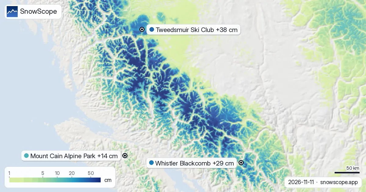
Water movement through early-season snow
In early season, new snow arrives loosely bonded. The crystals have not bonded into a solid layer; air spaces run from the surface deep into the base. When rain falls on this young snow, water finds a highway downslope.
The 35 cm that fell at Tweedsmuir yesterday sits atop existing frozen snow. Rain on November 13 will push water through the new layer in hours, not days. This creates what hydrologists call a rapid-flow layer. The water lubricates the bonds between crystals, weakening them. At the same time, the percolation rate can exceed the ability of the lower snowpack to refreeze the incoming liquid, so water pools and slides rather than bonding. This is what makes rain-on-snow on early-season powder particularly destabilizing.
| Resort | Snow depth | New snow, 72 h | Coming, next days | Top |
|---|---|---|---|---|
| Tweedsmuir Ski Club | 72 cm | 38 cm | 15 cm | 1,650 m |
| Whistler Blackcomb | 74 cm | 29 cm | 34 cm | 2,259 m |
| Mount Cain Alpine Park | 60 cm | 14 cm | 22 cm | 1,616 m |
Where fresh snow fell across the region
Tweedsmuir measured 38 cm of new snow over the past 72 hours, with 35 cm falling in the most recent 24 hours. This brought upper-slope depth to 72 cm. At mid-height (1619 m), our snow model shows 65 cm today—deeper than the same date in 33 of the past 46 winters. The seasonal normal here is 53 cm.
Whistler Blackcomb, to the south and west, received 29 cm in the same 72-hour window and now holds 74 cm at the top. Mount Cain, further north, accumulated 14 cm and reports 60 cm. Across Western Canada, 39 of 57 resorts now have measurable snow.
Freezing level contrast across the mountains
Tweedsmuir faces rain because of its modest elevation. Whistler Blackcomb sits higher—its peak reaches 2259 m—so the freezing level on November 13 will peak at 2870 m there, well above the summit. Whistler will get snow all day Friday.
Mount Cain, at 1616 m, sits between the two. Its freezing level on November 13 will peak at 2310 m, also well above the terrain, so Mount Cain also stays in snow. The hydrological advantage of height is clear: higher mountains can keep precipitation frozen when lower peaks cannot.
Snow forecast through November 14
Tweedsmuir will receive 12 cm on November 12 (before the rain arrives), 3 cm on November 13 (much falling as rain at the top), and 0 cm on November 14 when the freezing level drops back to between 1000 m and 1340 m.
Whistler's forecast is 34 cm total—16 cm on November 12, 1 cm on November 13, and 17 cm on November 14, all of it snow. Mount Cain will see 22 cm across the three days. The question for Tweedsmuir is not volume but phase: how much of the 3 cm on November 13 will fall as rain, and how will the existing snowpack respond?
What to expect after the rain event
If you ski Tweedsmuir on November 13, treat the conditions as unstable. The refrozen layer from that day will be firm but slick on November 14. Whistler's skiers can expect normal consolidation and stable snow.
By November 14, Tweedsmuir's freezing level will have dropped below the summit again, so snow arriving on the wet surface will bond—but consolidation of wet-base snow is unpredictable early in the season. This forecast is based on data from November 11. Check the official avalanche bulletin before heading uphill.
Tips for skiers
- On November 13, rain-on-snow at Tweedsmuir will increase instability. Check the official avalanche bulletin before entering terrain off the piste.
- The 35 cm that fell yesterday will bond better with what lies below after rain passes through, but watch for a slick layer where water percolated deepest.
- Whistler's slopes will stay drier and more stable through this event; Tweedsmuir faces the most challenge from the incoming rain.
- After November 13, pay attention to how fresh snow bonds with the wet base. Early-season consolidation is unpredictable.
- Use the SnowScope depth model to track how the snowpack changes at your preferred elevation through this rain-snow transition.
About these numbers
Resort snow depths are the deepest snow on the resort's upper slopes from the SnowScope snow model (about 1 km, run of 11 November); they are estimates for an area, not a measurement at one point. Station values are measurements on the date shown. Forecasts can change. Always read the official avalanche bulletin before going off-piste.
Official avalanche bulletins: Avalanche Canada
Cite this report
For research, teaching or the press: the numbers and charts are free to reuse under CC BY 4.0 with this citation.
SnowScope (2026), 1870 m: rain threat to Tweedsmuir's new powder, https://snowscope.app/blog/en/2026/11/western-canada-tweedsmuir-ski-club-fresh-snow-powder-alert-11-november-2026.html, accessed 2026-11-11
SnowScope (Atlas Labs). (2026, November 11). 1870 m: rain threat to Tweedsmuir's new powder. SnowScope snow reports. https://snowscope.app/blog/en/2026/11/western-canada-tweedsmuir-ski-club-fresh-snow-powder-alert-11-november-2026.html
BibTeX
@misc{snowscope2026westerncanadatweedsmuirs,
  author       = {{SnowScope (Atlas Labs)}},
  title        = {1870 m: rain threat to Tweedsmuir's new powder},
  year         = {2026},
  month        = nov,
  howpublished = {\url{https://snowscope.app/blog/en/2026/11/western-canada-tweedsmuir-ski-club-fresh-snow-powder-alert-11-november-2026.html}},
  note         = {Published 2026-11-11 18:44 UTC; accessed 2026-11-11}
}· CC BY 4.0 · Methods, data and tools →
Tweedsmuir Ski Club: snow and temperature by height, this winter vs last (tools) →
Follow Tweedsmuir Ski Club
Free: a message when fresh snow is coming, and the forecast every morning.

More snow reports

Whistler Blackcomb forecast to gain 47 centimetres by Saturday as snow arrives Thursday through the region, according to our model run on 4 November.
Manning Park Resort snow is at 23% of normal for mid-November. Here's what to bring for thin cover and the changing conditions ahead.
Western Canada's ski resorts hold snow at 18 percent of early-season norms as of November 3, with Mount Cain leading and lower elevations lagging far behind.