 SnowScope
Mt Baker ski area: a local's notebook on the snowiest small hill
Mt Baker is not a resort in the usual sense. There is no village and no hotel at the lifts, only day lodges at the end of a mountain road, and a lot of snow. These are the notes a regular would give a friend before a first visit, with our snow history of 46 past winters (a model, not resort reports) for the numbers.
See the live snow forecast for Mt Baker in the SnowScope appSnow depth, powder alerts and the 3D map, free.
Note one: the snow is the reason
Mt Baker holds the world's greatest recorded snowfall in one season, 1,140 in (29.0 m), in the winter of 1998-99, and its average is 641 in a year, among the highest of any ski area. Our model tells the same story on the ground: at mid-mountain, around 4,367 ft (1,331 m), the usual peak of the season is about 133 in (337 cm), and near the top, at 5,105 ft (1,556 m), about 210 in (533 cm).
Even in thin winters the hill is rarely bare. The leanest of the 46 winters still peaked at about 50 in (126 cm) at mid-mountain, the deepest at about 206 in (524 cm).
Note two: it is small, and that is fine
The area is modest on paper: a top at 5,089 ft (1,551 m), two bases at 3,500 ft (1,067 m) and 4,300 ft (1,310 m), a vertical drop of 1,589 ft (484 m) and about 1,000 acres. What makes it special is the terrain: steep gullies, cliffs and tree runs between the lifts, best for strong skiers and riders who like to explore. Beginners have gentle slopes near the lodges, but most of the mountain rewards experience.
Note three: the season starts late and ends late
Snow comes from the Pacific and needs time to build. In our model the first snow on the ground at mid-mountain usually comes around 26 October, and the usual depth there grows from about 47 in (119 cm) in December to about 76 in (193 cm) in January, 101 in (257 cm) in February and 114 in (289 cm) in March. April is almost as deep, about 112 in (285 cm), and near the top April is the deepest month, about 179 in (454 cm).
In 9 of 10 winters, mid-mountain had at least 20 in (50 cm) on the ground for 24 weeks of the season. Spring here is a serious option, not a leftover.
Note four: the road is part of the trip
The ski area sits at the end of State Route 542, the Mount Baker Highway, about 52 miles from Bellingham, roughly a 75-minute drive. There is no lodging at the hill, so most people stay in Bellingham or in the small towns along the highway. Carry chains and check the road before you leave: in a storm the last miles are snowy and slow.
Note five: respect the backcountry
The terrain beyond the boundary is tempting and close, and it is avalanche terrain with heavy, wet Pacific snow. Read the daily forecast of the Northwest Avalanche Center, go with partners and carry a transceiver, probe and shovel. Inside the area, follow closures: they are there for a reason after big storms.
What has changed
Our model compares the first 15 winters of the record with the last 15. At mid-mountain the usual peak moved from about 132 in (336 cm) to about 127 in (323 cm): a small drop on a very deep base. Last winter, 2025-26, peaked at about 106 in (269 cm) at mid-mountain, below the usual level but still a deep season by most standards.
Tips for skiers
- Book your bed in Bellingham or along the highway: there is none at the lifts.
- Come from January to April for the deepest snow; April is a good bet near the top.
- Drive with chains in the car and leave early on storm days.
- Never cross the boundary without the NWAC forecast, partners and rescue gear.
References and credits
- Wikipedia, 'Mt. Baker Ski Area' (retrieved 7 November 2026): elevations, vertical drop, skiable area, the 1998-99 snowfall record, average snowfall, State Route 542, distance from Bellingham, day lodges only. en.wikipedia.org/wiki/Mt._Baker_Ski_Area
- Mt. Baker Ski Area, official website. www.mtbaker.us/
- Northwest Avalanche Center (NWAC), official avalanche forecasts for the Cascades, including the Mt. Baker area. nwac.us/
About these numbers
Snow numbers: SnowScope snow history, 46 past winters (1980-81 to 2025-26) at three heights of the resort, a model of the past corrected for height (an estimate for an area, not resort reports). Lift, run and access facts: the sources listed below, checked on the date shown.
Official avalanche bulletins: avalanche.org (US national portal)
Cite this report
For research, teaching or the press: the numbers and charts are free to reuse under CC BY 4.0 with this citation.
SnowScope (2026), Mt Baker ski area: a local's notebook on the snowiest small hill, https://snowscope.app/blog/en/2026/11/mt-baker-ski-area-locals-notes.html, accessed 2026-11-09
SnowScope (Atlas Labs). (2026, November 9). Mt Baker ski area: a local's notebook on the snowiest small hill. SnowScope snow reports. https://snowscope.app/blog/en/2026/11/mt-baker-ski-area-locals-notes.html
BibTeX
@misc{snowscope2026mtbakerskiarealocalsnote,
  author       = {{SnowScope (Atlas Labs)}},
  title        = {Mt Baker ski area: a local's notebook on the snowiest small hill},
  year         = {2026},
  month        = nov,
  howpublished = {\url{https://snowscope.app/blog/en/2026/11/mt-baker-ski-area-locals-notes.html}},
  note         = {Published 2026-11-09 21:04 UTC; accessed 2026-11-09}
}· CC BY 4.0 · Methods, data and tools →
Mt Baker: snow and temperature by height, this winter vs last (tools) →
Follow Mt Baker
Free: a message when fresh snow is coming, and the forecast every morning.

More snow reports
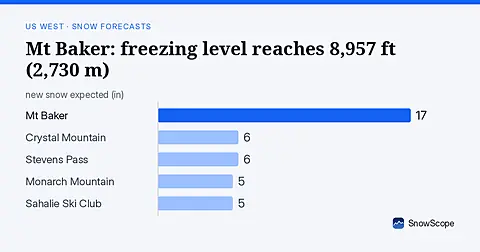
Rain will replace snow at Mt Baker on November 6, as the freezing level climbs to 8,957 ft (2,730 m), far above the ski area.
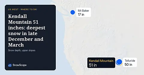
Kendall Mountain now has 51 inches on upper slopes as of November 5, 2026. Snow peaks in late December and March—the best historical windows to visit.
A storm on November 4 left 8 to 13 inches of new snow at five high Colorado stations near Aspen. Five days later, half of it was gone. What that means for powder days.