 SnowScope
Fresh snow in the US West: 11 in in 72 hours at Mt Baker (6 November)
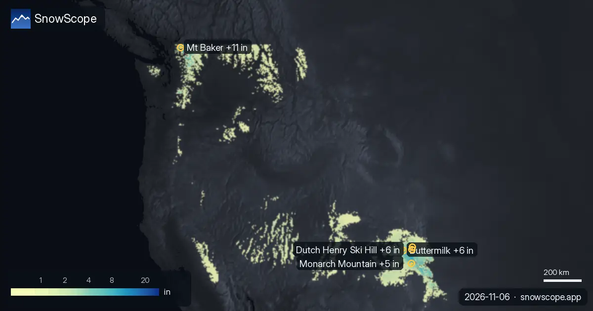
Mt Baker got 11 in (27 cm) of new snow in the last 72 hours, 4 in (11 cm) of it in the last 24 hours. It now has about 19 in (47 cm) on its upper slopes, according to our snow model.
See the live snow forecast for Mt Baker in the SnowScope appSnow depth, powder alerts and the 3D map, free.
The new snow
Elsewhere, Buttermilk, Dutch Henry Ski Hill and Ski Cooper got 6 in (15 cm), 6 in (15 cm) and 6 in (14 cm) in the last 72 hours.
Our snow model shows 82,506 sq mi (213,690 km²) of snow-covered ground in the US West today, with snow at 140 of 195 resorts.
| Resort | Snow depth | New snow, 72 h | Coming, next days | Top |
|---|---|---|---|---|
| Mt Baker | 19 in (47 cm) | 11 in (27 cm) | 13 in (33 cm) | 5,105 ft (1,556 m) |
| Buttermilk | 18 in (46 cm) | 6 in (15 cm) | 0 in (0 cm) | 9,882 ft (3,012 m) |
| Dutch Henry Ski Hill | 8 in (21 cm) | 6 in (15 cm) | 0 in (0 cm) | 10,026 ft (3,056 m) |
| Ski Cooper | 15 in (37 cm) | 6 in (14 cm) | 0 in (0 cm) | 11,742 ft (3,579 m) |
| Monarch Mountain | 12 in (30 cm) | 5 in (12 cm) | 0 in (0 cm) | 11,804 ft (3,598 m) |
Against past winters
At about 4,367 ft (1,331 m), Mt Baker has 6 in (14 cm) today; a normal 6 November has 4 in (10 cm) there.
Only one winter in ten has more than 26 in (66 cm) on this date.
A week ago the same spot had 7 in (18 cm).
In past winters the best snow at Mt Baker usually came late March / early April.
An early lead like this matters most for the lower and middle runs, which usually wait until December for this much snow.
Day by day at Mt Baker: Friday 6 November 4 in (11 cm); Saturday 7 November 2 in (6 cm); Sunday 8 November 10 in (25 cm); Monday 9 November 1 in (2 cm).
Height by height at Mt Baker: 3,629 ft (1,106 m) 2 in (5 cm) on the ground, 1 in (2 cm) more in the next 7 days; 4,367 ft (1,331 m) 6 in (15 cm) on the ground, 6 in (16 cm) more in the next 7 days; 5,105 ft (1,556 m) 10 in (25 cm) on the ground, 9 in (22 cm) more in the next 7 days.
What the stations measured
The Chepeta station (10,489 ft / 3,197 m) measured 20 in (51 cm) of snow on the ground on 1 November, with 12 in (30 cm) of new snow in 24 hours. The Red Mountain Pass station (11,060 ft / 3,371 m) measured 24 in (61 cm) of snow on the ground on 1 November, with 11 in (28 cm) of new snow in 24 hours. The Bison Lake station (10,951 ft / 3,338 m) measured 15 in (38 cm) of snow on the ground on 1 November, with 10 in (25 cm) of new snow in 24 hours.
Keep in mind: resort values come from our snow model and describe an area, while stations measure one point.
Height, slopes and snow line
Height matters: at Mt Baker, our model gives 10 in (25 cm) at the top (5,105 ft / 1,556 m), 6 in (15 cm) at mid-mountain (4,367 ft / 1,331 m) and 2 in (5 cm) at the base (3,629 ft / 1,106 m).
At Mt Baker, the freezing level reaches 4,003 ft (1,220 m) to 9,449 ft (2,880 m) on 6 November, above the top of the resort (5,105 ft / 1,556 m): rain or wet snow is possible on every slope that day.
The next days
Until 9 November, our forecast gives 13 in (33 cm) at Mt Baker.
Forecasts a few days ahead can change: look at the map again the day before you travel.
Safety and avalanche level
After fresh snow, wind builds drifts on sheltered slopes. Off-piste, the first days after a snowfall need the most care.
Tips for skiers
- Fresh snow is best in the first hours after it stops: go early, before the sun and the crowds.
- Look for snow high up and on north-facing slopes: they keep it longest, while south-facing slopes lose it first in the sun.
- Before you ski off-piste or go touring, read the official avalanche bulletin (links below).
- Snow on the map does not mean a resort is open: check lifts and opening dates on the resort's website.
- Get a powder alert in the SnowScope app to know when Mt Baker gets fresh snow.
About these numbers
Resort snow depths are the deepest snow on the resort's upper slopes from the SnowScope snow model (about 1 km, run of 5 November); they are estimates for an area, not a measurement at one point. Station values are measurements on the date shown. Forecasts can change. Always read the official avalanche bulletin before going off-piste.
Official avalanche bulletins: avalanche.org
Cite this report
For research, teaching or the press: the numbers and charts are free to reuse under CC BY 4.0 with this citation.
SnowScope (2026), Fresh snow in the US West: 11 in in 72 hours at Mt Baker (6 November), https://snowscope.app/blog/en/2026/11/us-west-fresh-snow-powder-alert-6-november-2026.html, accessed 2026-11-06
SnowScope (Atlas Labs). (2026, November 6). Fresh snow in the US West: 11 in in 72 hours at Mt Baker (6 November). SnowScope snow reports. https://snowscope.app/blog/en/2026/11/us-west-fresh-snow-powder-alert-6-november-2026.html
BibTeX
@misc{snowscope2026uswestfreshsnowpowderale,
  author       = {{SnowScope (Atlas Labs)}},
  title        = {Fresh snow in the US West: 11 in in 72 hours at Mt Baker (6 November)},
  year         = {2026},
  month        = nov,
  howpublished = {\url{https://snowscope.app/blog/en/2026/11/us-west-fresh-snow-powder-alert-6-november-2026.html}},
  note         = {Published 2026-11-06 15:30 UTC; accessed 2026-11-06}
}· CC BY 4.0 · Methods, data and tools →
Mt Baker: snow and temperature by height, this winter vs last (tools) →
Follow Mt Baker
Free: a message when fresh snow is coming, and the forecast every morning.

More snow reports
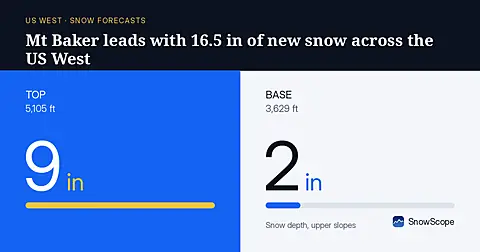
Mt Baker will receive 16.5 in (42 cm) of new snow through November 8, leading the US West, based on our model run on November 5.
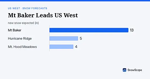
Mt Baker leads the US West with 19 in (47 cm) of upper snow, expecting 13 in (33 cm) through November 9. Model forecast from November 6.
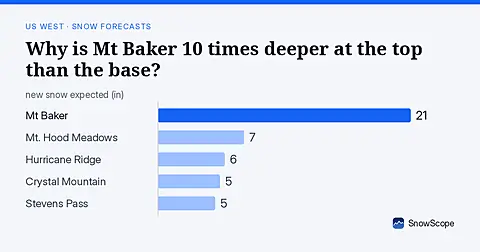
Mt Baker: 8 in (21 cm) at the summit versus less than 1 in (2 cm) at the base. November forecast shows how this height gap will shift.