 SnowScope
Méribel snow conditions: 24 cm at the top and 99 cm on the way (12 November 2026)
Méribel's winter is about to get its first proper delivery. The 11 November model run shows 24 cm at the top (2920 m), 1 cm at mid-mountain (2026 m) and nothing in the village at 1132 m, but the seven-day forecast is the headline: 99 cm of new snow at the top, 58 cm at mid-mountain and 3 cm in the valley, with 18 cm at the top in the next 24 hours alone.
See the live snow forecast for Méribel in the SnowScope appSnow depth, powder alerts and the 3D map, free.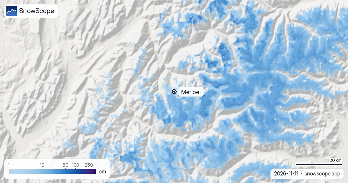
Where the snow is now
The top ridges of the resort, the Saulire and Mont Vallon side that link Méribel to Courchevel and Val Thorens in Les 3 Vallées, carry 24 cm after 18 cm in the last seven days. Mid-mountain, where most of the runs down to Mottaret are, has 1 cm, and the last week added 7 cm there. The valley is dry.
Treat the numbers as a model estimate for the area: a stake in a shaded combe will read more, a sunny slope less, and early snow is water that the ground and the sun still take a share of.
The week ahead
The forecast puts 99 cm at the top and 58 cm at mid-mountain within seven days, 18 cm at the top in the first 24 hours. If it falls as modelled, mid-mountain goes from 1 cm to a first base in a single week, and the top passes a usual November.
A forecast of this size carries a wide margin: the first storm is the sure part, the total is not. Wind on the high ridges will also move a lot of it into the combes.
Méribel against its own past
Over our 46 past winters (1980-81 to 2025-26) the first snow lies at the top by 26 September, at mid-mountain by 11 October and in the valley by 3 November. A usual November holds 4 cm at the base, 19 cm at mid-mountain and 62 cm at the top; December climbs to 20, 55 and 139 cm.
The peak of a middle winter is 54 cm in the valley, 159 cm at mid-mountain and 343 cm at the top, and 18 weeks of the winter have 50 cm or more at mid-mountain in 9 of 10 winters. Last winter peaked at 67, 174 and 312 cm.
For a December booking
Méribel's deepest months up high are March and April (267 cm and 297 cm at the top), but December is already comfortable at mid-mountain in most winters (55 cm). The mapped area counts 142 km of runs and 46 lifts between 1132 m and 2920 m. Watch this week's storm, then the December line.
Tips for skiers
- Watch the next 24 hours at the top: 18 cm is the part of the forecast you can count on.
- Fresh snow on a 1 cm base is not a skiable base: wait for the resort's opening and its own piste report.
- Large new-snow totals raise the avalanche danger: the Météo-France bulletin applies to any off-piste plan.
More maps (external sites)
References and credits
- Méribel, official site (lifts, opening dates, piste report) www.meribel.net/
- Météo-France, mountain weather and avalanche bulletins meteofrance.com/meteo-montagne
About these numbers
Snow numbers: the SnowScope snow model, run of 11 November 2026, at three heights of the resort (a model estimate for the area, not resort measurements), and our snow history, 46 past winters (1980-81 to 2025-26), a model of the past corrected for height. Run length and lift count: OpenSkiMap mapping. Forecasts change: look at the map before you go.
Official avalanche bulletins: Météo-France – Bulletin d'estimation du risque d'avalanche
Cite this report
For research, teaching or the press: the numbers and charts are free to reuse under CC BY 4.0 with this citation.
SnowScope (2026), Méribel snow conditions: 24 cm at the top and 99 cm on the way (12 November 2026), https://snowscope.app/blog/en/2026/11/meribel-snow-conditions-12-november-2026.html, accessed 2026-11-12
SnowScope (Atlas Labs). (2026, November 12). Méribel snow conditions: 24 cm at the top and 99 cm on the way (12 November 2026). SnowScope snow reports. https://snowscope.app/blog/en/2026/11/meribel-snow-conditions-12-november-2026.html
BibTeX
@misc{snowscope2026meribelsnowconditions12n,
  author       = {{SnowScope (Atlas Labs)}},
  title        = {Méribel snow conditions: 24 cm at the top and 99 cm on the way (12 November 2026)},
  year         = {2026},
  month        = nov,
  howpublished = {\url{https://snowscope.app/blog/en/2026/11/meribel-snow-conditions-12-november-2026.html}},
  note         = {Published 2026-11-12 09:23 UTC; accessed 2026-11-12}
}· CC BY 4.0 · Methods, data and tools →
Méribel: snow and temperature by height, this winter vs last (tools) →
Follow Méribel
Free: a message when fresh snow is coming, and the forecast every morning.

More snow reports
Seven days in the Silvretta Arena, one at a time: where the snow is, when to cross to Samnaun, and what 46 past winters say about Ischgl's snow at three heights.
Davos and Klosters share six ski mountains. A day-by-day plan, starting on Parsenn, with what 46 past winters of our snow history say about its heights.
When to book Courchevel and the 3 Vallées, which village to stay in and where the snow lasts, planned from 46 past winters of snow data.