 SnowScope
Slope angle and avalanches: what 30°, 35° and 40° really mean on the mountain
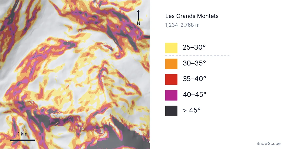
Look at the map first. Every coloured patch is ground steeper than 25°, and everything below the dashed line in the legend is steeper than 30°. Around Les Grands Montets above Argentière, almost half of the mountain between the lowest and the highest lift is in that second group. That one number explains a lot about avalanches.
See the live snow forecast for Les Grands Montets in the SnowScope appSnow depth, powder alerts and the 3D map, free.
What the map shows
We cut a square of 3 km in every direction around the centre of each ski area and kept only the ground between its lowest and its highest lift. Then we measured the angle of every small square of terrain, about 13 m on a side. The colours follow five steps: 25–30°, 30–35°, 35–40°, 40–45° and steeper than 45°.
At Les Grands Montets (1,234–2,768 m) the result is 47 % of the ground steeper than 30°, 28 % steeper than 35° and 14 % steeper than 40°. The steepest square on our map reaches 67°. That is rock, not a ski run, and the map is honest enough to show it in dark grey.
So the picture is not a piste map. It shows the shape of the mountain itself: the open bowls, the gullies, the rock walls and the gentle shoulders where the lifts arrive.
Why 30° is the line to remember
An avalanche starts when a layer of snow can no longer hold on to the layer below it. On gentle ground, gravity pulls the snow mostly into the slope, so the layers stay where they are. As the slope gets steeper, more of that pull goes down the hill. Studies of real avalanches find that most dry slab avalanches start on slopes between about 30° and 45°. A slab is a block of firm snow that breaks away in one piece, and it is the type that catches most skiers.
Below about 30°, slab avalanches are rare. Above about 45°, snow often slides off in small amounts during the storm itself, so big slabs build up less often. The band in between is where the snow is steep enough to fail and still holds enough snow to be dangerous.
That is why the app's new Slope steepness layer draws its dashed line at 30°. It is not a safety line. It is the point where the question changes from "is it steep?" to "what is the snow doing today?"
Eight ski areas side by side
The same method around seven other ski areas gives very different mountains. St. Anton comes close to Les Grands Montets: 45 % of the ground is steeper than 30°, 27 % steeper than 35° and 14 % steeper than 40°. Jackson Hole follows with 38 %, 20 % and 10 %.
Kicking Horse (32 % steeper than 30°) and the area around Verbier (31 %) sit in the middle. KitzSki has 28 % above 30° but only 4 % above 40°. Whistler Blackcomb and Seiser Alm are the gentlest in our list, with 15 % of the ground steeper than 30° each.
Be careful with these numbers. They describe the land inside our square, not the marked runs. Whistler Blackcomb has plenty of steep alpine terrain; our square around its centre simply also holds a lot of forest and gentle slopes. A low number means "less steep ground in this window", not "no avalanche terrain".
How sure can we be?
A map like this smooths the ground. Each square is about 13 m wide, so a short, steep roll, a cornice or the lip of a gully can be steeper than any square on the map. In practice, the real slope is often a few degrees steeper than the map says, never gentler in a way you should trust.
The angle that matters is also the angle of the start zone above you, not only the slope under your skis. A flat valley floor can be hit by an avalanche that started on a 40° face high above it. On our map, that flat floor stays white. Your eyes have to add the rest.
In short: the colours tell you where the terrain can produce avalanches. They do not tell you whether it will today. Only the snow and the weather decide that, and the avalanche bulletin is where that decision is written down every day.
Reading 30°, 35° and 40° on the ground
30–35° (orange on the map): many classic off-piste slopes and the steeper black runs sit here. Avalanches are possible whenever the snowpack has a weak layer. Most people underestimate this band because it does not feel very steep.
35–40° (red): a steep slope by any standard. A fall here can be long, and a slab that breaks can run fast. This is the band where the largest number of skier-triggered avalanches start.
40–45° (purple) and steeper (dark grey): couloirs, faces and rock bands. Snow sometimes sluffs off here, which means that small loose surface snow runs down the slope. Sluffs are small, but they can push you over a cliff.
One simple field check: hold two ski poles of the same length, one hanging straight down and one touching the slope at the point where the first pole meets the snow. It takes a little practice, and an inclinometer on a phone or a compass is easier. Measure in the steepest part, not where you stand.
Tips for skiers
- Use slope angle to plan, not to decide: steep ground is where avalanches can start, the bulletin says if they are likely today.
- Look up: the slope above you matters as much as the slope under you.
- Trust the map less on small features; rolls, gullies and the top of a couloir are often steeper than shown.
- Always check the official avalanche bulletin before going off-piste, and carry and know how to use transceiver, shovel and probe.
References and credits
- Schweizer, J., Jamieson, J. B. and Schneebeli, M. (2003). Snow avalanche formation. Reviews of Geophysics 41(4), 1016. doi.org/10.1029/2002RG000123
- European Avalanche Warning Services: official avalanche bulletins of every European region. www.avalanches.org/
- SnowScope: La Grave myths and facts – off-piste skiing and snow under La Meije. snowscope.app/blog/en/2026/11/la-grave-myths-and-facts-off-piste-la-meije.html
About these numbers
Slope angles: SnowScope terrain analysis of an open elevation model (tiles of about 13 m), Horn's 3x3 method, classes of the app's Slope steepness layer (25, 30, 35, 40, 45°). Window: 3 km around each ski area's centre, ground between its lowest and highest mapped lift. Steepness only: this is not an avalanche risk map.
Cite this report
For research, teaching or the press: the numbers and charts are free to reuse under CC BY 4.0 with this citation.
SnowScope (2026), Slope angle and avalanches: what 30°, 35° and 40° really mean on the mountain, https://snowscope.app/blog/en/2026/11/slope-angle-avalanche-terrain-30-35-40-degrees.html, accessed 2026-11-10
SnowScope (Atlas Labs). (2026, November 10). Slope angle and avalanches: what 30°, 35° and 40° really mean on the mountain. SnowScope snow reports. https://snowscope.app/blog/en/2026/11/slope-angle-avalanche-terrain-30-35-40-degrees.html
BibTeX
@misc{snowscope2026slopeangleavalancheterra,
  author       = {{SnowScope (Atlas Labs)}},
  title        = {Slope angle and avalanches: what 30°, 35° and 40° really mean on the mountain},
  year         = {2026},
  month        = nov,
  howpublished = {\url{https://snowscope.app/blog/en/2026/11/slope-angle-avalanche-terrain-30-35-40-degrees.html}},
  note         = {Published 2026-11-10 17:43 UTC; accessed 2026-11-10}
}· CC BY 4.0 · Methods, data and tools →
Les Grands Montets: snow and temperature by height, this winter vs last (tools) →
Follow Les Grands Montets
Free: a message when fresh snow is coming, and the forecast every morning.

More snow reports
Whistler Blackcomb received 100 cm of fresh snow in 72 hours to 8 November, but it fell unevenly: 96 cm at the summit, none at the base.
Snow on 3 November 2026: Kendall Mountain 53 in (134 cm) after a storm, Big White 91 cm, the Alps up to 55 cm at Bonneval-sur-Arc. Model and station data.
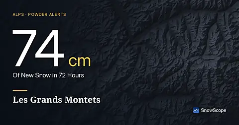
Les Grands Montets saw 74 cm of new snow in the last 72 hours, with more forecast for the coming days, according to our model on November 17, 2026.