 SnowScope
Whistler storm: about 92 cm up high, rain on the North Shore – the next days in motion
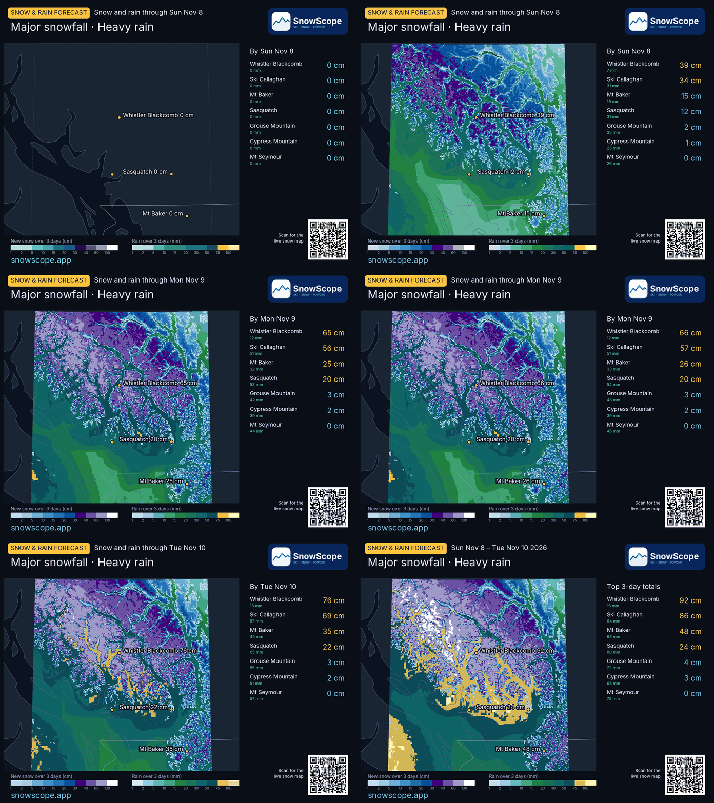
A wet Pacific storm reaches the Coast Mountains. Our snow model gives about 92 cm of new snow on the upper slopes of Whistler Blackcomb from 8 to 10 November, while the mountains above Vancouver mostly get rain: 72 mm at Grouse Mountain with only 4 cm of snow.
See the live snow forecast for Whistler Blackcomb in the SnowScope appSnow depth, powder alerts and the 3D map, free.
Snow up high, rain down low
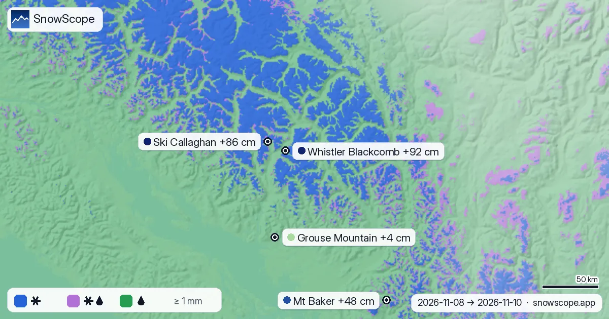
The animation shows the storm building day by day. The deepest new snow is in the high terrain north of Squamish: 92 cm at Whistler Blackcomb and 86 cm at Ski Callaghan. South of the border, Mt Baker gets 48 cm.
The North Shore is a different story. Cypress Mountain gets 68 mm of rain and 3 cm of snow, Mt Seymour 75 mm of rain and no new snow at all. The difference is height: these areas top out where the storm is still rain.
Where is the snow line?
Over the wet hours the snow line across the region sits mostly between 1,190 and 2,230 m, with a middle value near 1,620 m. At 2,000 m about 70 % of the precipitation should fall as snow; at 1,500 m only 28 %, with 26 % wet snow and 46 % rain.
At Whistler itself the 0 °C level stands near 2,100 m during the rain, so the snow line is near 1,800 m: the alpine gets snow, the village and the lower runs mostly rain. The forecast gives 110 mm of precipitation there from 8 to 12 November.

Show the numbers
| Date | Whistler Blackcomb (cm) | Ski Callaghan (cm) | Mt Baker (cm) | Sasquatch (cm) | Grouse Mountain (cm) |
|---|---|---|---|---|---|
| 8 November * | 65 | 58 | 25 | 20 | 3 |
| 9 November * | 1 | 1 | 1 | 0 | 0 |
| 10 November * | 26 | 30 | 22 | 4 | 1 |
The physics: a warm, wet storm meets a wall of mountains
Air coming off the Pacific is mild and full of water vapour. When the wind pushes it against the Coast Mountains it has to rise, it cools and the vapour condenses into heavy rain and snow on the slopes facing the wind.
Because the air is mild, the 0 °C level stays high. Snow melts as it falls through the warmer air and turns to rain about 300 m below the 0 °C level. A few hundred metres of height therefore decide between a powder day and a soaking.

Show the numbers
| Height (m) | Snow % | Wet snow / sleet % | Rain % |
|---|---|---|---|
| 500 | 0 | 0 | 100 |
| 750 | 0 | 0 | 100 |
| 1,000 | 0 | 7 | 93 |
| 1,250 | 3 | 30 | 67 |
| 1,500 | 28 | 26 | 46 |
| 1,750 | 50 | 23 | 27 |
| 2,000 | 70 | 17 | 13 |
| 2,250 | 85 | 10 | 5 |
| 2,500 | 94 | 5 | 1 |
| 2,750 | 99 | 1 | 0 |
| 3,000 | 100 | 0 | 0 |
What it means for you
- Forecasts change: check the live snow map again before you go.
- Heavy new snow on a wet base: in the backcountry, read the Avalanche Canada forecast first.
- Driving the Sea-to-Sky: expect rain in the valley and snow on higher roads.
References and credits
- Roe, G. H. (2005). Orographic precipitation. Annual Review of Earth and Planetary Sciences 33, 645-671. doi.org/10.1146/annurev.earth.33.092203.122541
- Minder, J. R., Durran, D. R. and Roe, G. H. (2011). Mesoscale controls on the mountainside snow line. Journal of the Atmospheric Sciences 68, 2107-2127. doi.org/10.1175/JAS-D-10-05006.1
- American Meteorological Society, Glossary of Meteorology: 'Orographic precipitation'. glossary.ametsoc.org/wiki/Orographic_precipitation
- American Meteorological Society, Glossary of Meteorology: 'Freezing level'. glossary.ametsoc.org/wiki/Freezing_level
- Wallace, J. M. and Hobbs, P. V. (2006). Atmospheric Science: An Introductory Survey, 2nd edition. Academic Press / Elsevier. ISBN 978-0-12-732951-2.
- Open-Meteo.com forecast API, ECMWF IFS 0.25° model (CC BY 4.0): hourly precipitation and temperature on pressure levels. open-meteo.com/en/docs/ecmwf-api
- SnowScope snow model and forecast maps (SnowScope, Atlas Labs). snowscope.app/
About these numbers
New snow per resort: SnowScope snow model (500 m grid, upper-slope value), 8 to 10 November, run of 7 November. Snow line: ECMWF IFS (via Open-Meteo) hourly precipitation and temperature profile at 54 points; snow line = 0 °C level minus 300 m, wet snow within 150 m of it. Forecasts change.
Cite this report
For research, teaching or the press: the numbers and charts are free to reuse under CC BY 4.0 with this citation.
SnowScope (2026), Whistler storm: about 92 cm up high, rain on the North Shore – the next days in motion, https://snowscope.app/blog/en/2026/11/whistler-storm-snow-up-high-rain-below-8-10-november-2026.html, accessed 2026-11-08
SnowScope (Atlas Labs). (2026, November 8). Whistler storm: about 92 cm up high, rain on the North Shore – the next days in motion. SnowScope snow reports. https://snowscope.app/blog/en/2026/11/whistler-storm-snow-up-high-rain-below-8-10-november-2026.html
BibTeX
@misc{snowscope2026whistlerstormsnowuphighr,
  author       = {{SnowScope (Atlas Labs)}},
  title        = {Whistler storm: about 92 cm up high, rain on the North Shore – the next days in motion},
  year         = {2026},
  month        = nov,
  howpublished = {\url{https://snowscope.app/blog/en/2026/11/whistler-storm-snow-up-high-rain-below-8-10-november-2026.html}},
  note         = {Published 2026-11-08 14:35 UTC; accessed 2026-11-08}
}· CC BY 4.0 · Methods, data and tools →
Follow Whistler Blackcomb
Free: a message when fresh snow is coming, and the forecast every morning.

More snow reports

Whistler Blackcomb for every level, with our snow history: about 370 cm at the usual peak at mid-mountain over 46 past winters, March and April the deepest months.
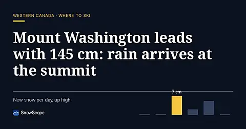
Mount Washington holds 145 cm on 8 November, the deepest in Western Canada, but the freezing level will climb above the summit by 11 November.
Western Canada's ski resorts hold snow at 18 percent of early-season norms as of November 3, with Mount Cain leading and lower elevations lagging far behind.